

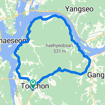
태전동, 광주시에서 태전동, 광주시까지
A cycling route starting in Gwangju, Gyeonggi-do, Republic of Korea.
Overview
About this route
- 24 min
- Duration
- 7.3 km
- Distance
- 42 m
- Ascent
- 43 m
- Descent
- 18.1 km/h
- Avg. speed
- 69 m
- Avg. speed
Continue with Bikemap
Use, edit, or download this cycling route
You would like to ride 태전동, 광주시에서 태전동, 광주시까지 or customize it for your own trip? Here is what you can do with this Bikemap route:
Free features
- Save this route as favorite or in collections
- Copy & plan your own version of this route
- Sync your route with Garmin or Wahoo
Premium features
Free trial for 3 days, or one-time payment. More about Bikemap Premium.
- Navigate this route on iOS & Android
- Export a GPX / KML file of this route
- Create your custom printout (try it for free)
- Download this route for offline navigation
Discover more Premium features.
Get Bikemap PremiumFrom our community
Other popular routes starting in Gwangju
 분원리 한바퀴
- Distance
- 29.4 km
- Ascent
- 333 m
- Descent
- 346 m
- Location
- Gwangju, Gyeonggi-do, Republic of Korea
 용인 광주
용인 광주- Distance
- 47.9 km
- Ascent
- 86 m
- Descent
- 84 m
- Location
- Gwangju, Gyeonggi-do, Republic of Korea
 현진이와 첫번째 자전거 라이딩 청석공원
- Distance
- 11.5 km
- Ascent
- 75 m
- Descent
- 41 m
- Location
- Gwangju, Gyeonggi-do, Republic of Korea
 초월읍 697-12, 광주시 ~ 진건읍 48-7, 남양주시
- Distance
- 47.3 km
- Ascent
- 369 m
- Descent
- 309 m
- Location
- Gwangju, Gyeonggi-do, Republic of Korea
 쌍령동, 광주시에서 쌍령동, 광주시까지
- Distance
- 29.6 km
- Ascent
- 90 m
- Descent
- 77 m
- Location
- Gwangju, Gyeonggi-do, Republic of Korea
 곤지암 리조트 - 분당 - 곤지암 리조트 - 분당
- Distance
- 38.8 km
- Ascent
- 472 m
- Descent
- 590 m
- Location
- Gwangju, Gyeonggi-do, Republic of Korea
 오포읍 464-6, 광주시 ~ 오포읍 606-5, 광주시
- Distance
- 4.5 km
- Ascent
- 9 m
- Descent
- 66 m
- Location
- Gwangju, Gyeonggi-do, Republic of Korea
 태전동, 광주시에서 태전동, 광주시까지
- Distance
- 7.3 km
- Ascent
- 42 m
- Descent
- 43 m
- Location
- Gwangju, Gyeonggi-do, Republic of Korea
Open it in the app