

100 Km on Warden N and Kennedy S
A cycling route starting in Markham, Ontario, Canada.
Overview
About this route
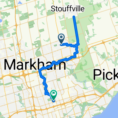
100 Km Loop starting at Major Mack on Warden
North of Warden to Morton Pollock Rd
West on Pollock Rd to Woodbine ave (1st Break)
North on Woodbine Ave to Old Homestead Rd
East on Old Homestead Rd to Warden
North on Warden to Base Line Rd
East on Baseline to Kennedy
South on Kennedy to Mt Albert Rd
West on Mt Albert Rd to Woodbine (2nd Break)
South on Woobine to Davis
South on Kennedy unit Major Mack
- -:--
- Duration
- 103.8 km
- Distance
- 285 m
- Ascent
- 295 m
- Descent
- ---
- Avg. speed
- ---
- Avg. speed

Continue with Bikemap
Use, edit, or download this cycling route
You would like to ride 100 Km on Warden N and Kennedy S or customize it for your own trip? Here is what you can do with this Bikemap route:
Free features
- Save this route as favorite or in collections
- Copy & plan your own version of this route
- Sync your route with Garmin or Wahoo
Premium features
Free trial for 3 days, or one-time payment. More about Bikemap Premium.
- Navigate this route on iOS & Android
- Export a GPX / KML file of this route
- Create your custom printout (try it for free)
- Download this route for offline navigation
Discover more Premium features.
Get Bikemap PremiumFrom our community
Other popular routes starting in Markham
 Angus Glen to Lake Simcoe via Warden
- Distance
- 106.3 km
- Ascent
- 670 m
- Descent
- 668 m
- Location
- Markham, Ontario, Canada
 Reesor to Chalk Lake
- Distance
- 62.4 km
- Ascent
- 352 m
- Descent
- 357 m
- Location
- Markham, Ontario, Canada
 Mount Joy to Agincourt Via Organics Farm
- Distance
- 44.2 km
- Ascent
- 166 m
- Descent
- 199 m
- Location
- Markham, Ontario, Canada
 Mount Joy to Don Mills Via Organics Farm
- Distance
- 46.9 km
- Ascent
- 187 m
- Descent
- 210 m
- Location
- Markham, Ontario, Canada
 48 km loop @ McCowan, Vivian, Warden
- Distance
- 48.1 km
- Ascent
- 221 m
- Descent
- 219 m
- Location
- Markham, Ontario, Canada
 Unionville to Organics Farm Via Rouge River Trail
- Distance
- 37.5 km
- Ascent
- 177 m
- Descent
- 150 m
- Location
- Markham, Ontario, Canada
 Saturday Local Country Ride
- Distance
- 75.4 km
- Ascent
- 328 m
- Descent
- 326 m
- Location
- Markham, Ontario, Canada
 115km loop with 3 Gas Statiosn for Break
- Distance
- 118.7 km
- Ascent
- 409 m
- Descent
- 409 m
- Location
- Markham, Ontario, Canada
Open it in the app