

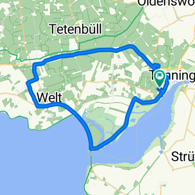
Route in Tönning
A cycling route starting in Tönning, Schleswig-Holstein, Germany.
Overview
About this route
- 3 h 17 min
- Duration
- 43.9 km
- Distance
- 8 m
- Ascent
- 7 m
- Descent
- 13.4 km/h
- Avg. speed
- 6 m
- Avg. speed

Route quality
Waytypes & surfaces along the route
Waytypes
Quiet road
19.7 km
(45 %)
Road
6.7 km
(15 %)
Surfaces
Paved
25.2 km
(57 %)
Unpaved
7 km
(16 %)
Asphalt
23.1 km
(53 %)
Ground
4.8 km
(11 %)
Continue with Bikemap
Use, edit, or download this cycling route
You would like to ride Route in Tönning or customize it for your own trip? Here is what you can do with this Bikemap route:
Free features
- Save this route as favorite or in collections
- Copy & plan your own version of this route
- Sync your route with Garmin or Wahoo
Premium features
Free trial for 3 days, or one-time payment. More about Bikemap Premium.
- Navigate this route on iOS & Android
- Export a GPX / KML file of this route
- Create your custom printout (try it for free)
- Download this route for offline navigation
Discover more Premium features.
Get Bikemap PremiumFrom our community
Other popular routes starting in Tönning
 Wikinger-Friesen-Weg3_Teilstr1
- Distance
- 24 km
- Ascent
- 0 m
- Descent
- 0 m
- Location
- Tönning, Schleswig-Holstein, Germany
 Tönning, Sperrwerk, Welt Garding, Tönning
- Distance
- 33.6 km
- Ascent
- 10 m
- Descent
- 10 m
- Location
- Tönning, Schleswig-Holstein, Germany
 Ostsee 12: Tönning-Meldorf 48,3km 0hm
- Distance
- 49.7 km
- Ascent
- 11 m
- Descent
- 9 m
- Location
- Tönning, Schleswig-Holstein, Germany
 Nordseeküstenradweg 2015_Teil 4
- Distance
- 74.2 km
- Ascent
- 14 m
- Descent
- 11 m
- Location
- Tönning, Schleswig-Holstein, Germany
 Tönning nach St Peter 75 km
- Distance
- 76.6 km
- Ascent
- 4 m
- Descent
- 4 m
- Location
- Tönning, Schleswig-Holstein, Germany
 Etappe 15
- Distance
- 104.1 km
- Ascent
- 83 m
- Descent
- 85 m
- Location
- Tönning, Schleswig-Holstein, Germany
 awv52H4-Tönning-StPeter Ording H
- Distance
- 37.4 km
- Ascent
- 5 m
- Descent
- 6 m
- Location
- Tönning, Schleswig-Holstein, Germany
 Wikingerweg - Von Tönning nach Güby
- Distance
- 86.7 km
- Ascent
- 137 m
- Descent
- 93 m
- Location
- Tönning, Schleswig-Holstein, Germany
Open it in the app