
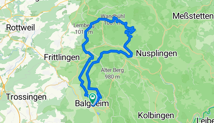
MB-Tour Heuberg-Tanneck
A cycling route starting in Balgheim, Baden-Württemberg, Germany.
Overview
About this route
MB-Tour auf Waldwegen mit teilweise langen Steigungen. / Kurze Abschnitte auf Teerwegen u. Kreisstraße.
- 4 h 32 min
- Duration
- 50.6 km
- Distance
- 1,275 m
- Ascent
- 1,279 m
- Descent
- 11.2 km/h
- Avg. speed
- 1,003 m
- Avg. speed
Route quality
Waytypes & surfaces along the route
Waytypes
Track
39.6 km
(78 %)
Quiet road
5.9 km
(12 %)
Surfaces
Paved
8 km
(16 %)
Unpaved
36.5 km
(72 %)
Gravel
34.3 km
(68 %)
Asphalt
6 km
(12 %)
Continue with Bikemap
Use, edit, or download this cycling route
You would like to ride MB-Tour Heuberg-Tanneck or customize it for your own trip? Here is what you can do with this Bikemap route:
Free features
- Save this route as favorite or in collections
- Copy & plan your own version of this route
- Sync your route with Garmin or Wahoo
Premium features
Free trial for 3 days, or one-time payment. More about Bikemap Premium.
- Navigate this route on iOS & Android
- Export a GPX / KML file of this route
- Create your custom printout (try it for free)
- Download this route for offline navigation
Discover more Premium features.
Get Bikemap PremiumFrom our community
Other popular routes starting in Balgheim
 Balgheim - Heuberg - Donautal
- Distance
- 72.5 km
- Ascent
- 1,144 m
- Descent
- 1,170 m
- Location
- Balgheim, Baden-Württemberg, Germany
 Rundkurs nach Niedereschach 55 km
- Distance
- 55.2 km
- Ascent
- 705 m
- Descent
- 705 m
- Location
- Balgheim, Baden-Württemberg, Germany
 Balgheim nach Bodman-Ludwigshafen
- Distance
- 46.8 km
- Ascent
- 566 m
- Descent
- 860 m
- Location
- Balgheim, Baden-Württemberg, Germany
 Schloßäckerweg 15, Balgheim nach Dürbheimer Straße 18, Balgheim
- Distance
- 17.3 km
- Ascent
- 477 m
- Descent
- 481 m
- Location
- Balgheim, Baden-Württemberg, Germany
 Talheim-Esslingen-Kohlhalde
- Distance
- 40.2 km
- Ascent
- 677 m
- Descent
- 671 m
- Location
- Balgheim, Baden-Württemberg, Germany
 B14, Balgheim nach Uhldingen-Mühlhofen
- Distance
- 62.8 km
- Ascent
- 566 m
- Descent
- 855 m
- Location
- Balgheim, Baden-Württemberg, Germany
 Unnamed Road, Balgheim nach Unnamed Road, Balgheim
- Distance
- 9.8 km
- Ascent
- 306 m
- Descent
- 308 m
- Location
- Balgheim, Baden-Württemberg, Germany
 MB-Tour Heuberg-Tanneck
- Distance
- 50.6 km
- Ascent
- 1,275 m
- Descent
- 1,279 m
- Location
- Balgheim, Baden-Württemberg, Germany
Open it in the app