
Muskiz - Cerredo
A cycling route starting in San Julián de Muskiz, Basque Country, Spain.
Overview
About this route
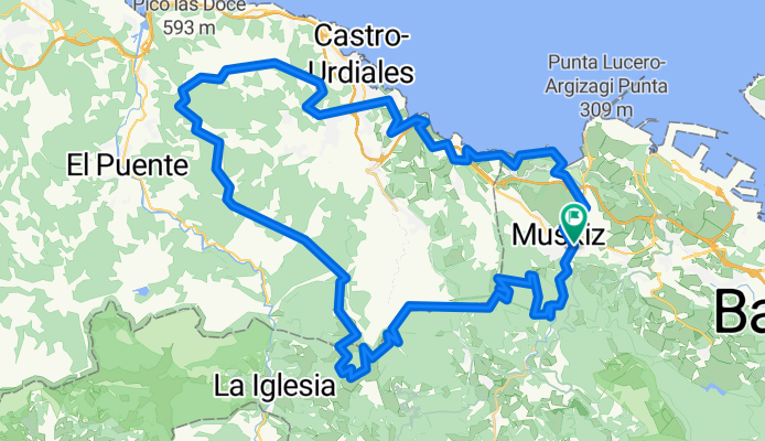
<div>Ruta que parte y finaliza en Muskiz. Es bastante exigente ya que llega hasta Castro (Km.52) atravesando monte y casi íntegramente por pistas. La vuelta es mas suave ya que se realiza por la carretera nacional hasta Ontón, donde se cogen la Via Verde del Piquillo y la de Itsaslur.</div> <div><br /></div> <div>El recorrido resumido es:</div> <div><br /></div> <div>Muskiz - El Pobal - Monte Mello (633m) - Alto de las Muñecas - Faldas del Monte Alen - Bajada dirección Artzentales - Monte Ventoso (731m) - Puerto de la Granja - Alto de la Haya (395m) - Repetidor Monte Cerredo (590m) - Castro - Mioño - Onton - VV del Piquillo - Kobaron - VV Paseo de Itsaslur - Pobeña - Muskiz</div>
- -:--
- Duration
- 70.6 km
- Distance
- 1,705 m
- Ascent
- 1,705 m
- Descent
- ---
- Avg. speed
- ---
- Avg. speed
Continue with Bikemap
Use, edit, or download this cycling route
You would like to ride Muskiz - Cerredo or customize it for your own trip? Here is what you can do with this Bikemap route:
Free features
- Save this route as favorite or in collections
- Copy & plan your own version of this route
- Sync your route with Garmin or Wahoo
Premium features
Free trial for 3 days, or one-time payment. More about Bikemap Premium.
- Navigate this route on iOS & Android
- Export a GPX / KML file of this route
- Create your custom printout (try it for free)
- Download this route for offline navigation
Discover more Premium features.
Get Bikemap PremiumFrom our community
Other popular routes starting in San Julián de Muskiz
 Via Verde "La Galdamesa"
- Distance
- 13.2 km
- Ascent
- 479 m
- Descent
- 476 m
- Location
- San Julián de Muskiz, Basque Country, Spain
 Subidas a La Arboleda (5)
- Distance
- 108.3 km
- Ascent
- 2,174 m
- Descent
- 2,174 m
- Location
- San Julián de Muskiz, Basque Country, Spain
 Las Carreras-Espinosa de los Monteros (La Sía-Lunada-Caracol-Estacas)
- Distance
- 174.1 km
- Ascent
- 3,433 m
- Descent
- 2,752 m
- Location
- San Julián de Muskiz, Basque Country, Spain
 Peña angulo por añes.
- Distance
- 133.7 km
- Ascent
- 1,487 m
- Descent
- 1,489 m
- Location
- San Julián de Muskiz, Basque Country, Spain
 Cantabria costera
- Distance
- 206.2 km
- Ascent
- 343 m
- Descent
- 343 m
- Location
- San Julián de Muskiz, Basque Country, Spain
 Excursión Amistad Bilbao 2018 - 8
- Distance
- 95.5 km
- Ascent
- 1,465 m
- Descent
- 1,465 m
- Location
- San Julián de Muskiz, Basque Country, Spain
 Recorrido: Excursión Amistad Bilbao 2018 - 7
- Distance
- 112.5 km
- Ascent
- 1,764 m
- Descent
- 1,764 m
- Location
- San Julián de Muskiz, Basque Country, Spain
 Picon y vuelta por escrita
- Distance
- 179.3 km
- Ascent
- 2,314 m
- Descent
- 2,318 m
- Location
- San Julián de Muskiz, Basque Country, Spain
Open it in the app