
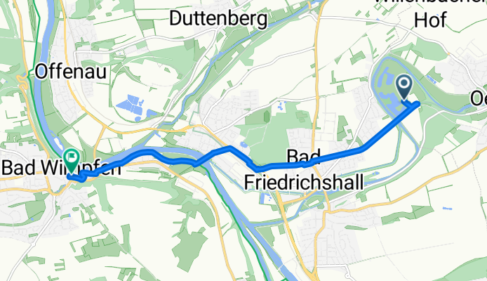
4. Etappe Von Hagenbach bis Bad Friedrichshall
A cycling route starting in Oedheim, Baden-Württemberg, Germany.
Overview
About this route
Autor: Forchtenberg - Autor: Forchtenberg
- 27 min
- Duration
- 6.8 km
- Distance
- 66 m
- Ascent
- 24 m
- Descent
- 15.2 km/h
- Avg. speed
- 198 m
- Avg. speed

Route quality
Waytypes & surfaces along the route
Waytypes
Path
2.8 km
(41 %)
Track
1.2 km
(18 %)
Surfaces
Paved
6.5 km
(96 %)
Asphalt
6.3 km
(92 %)
Metal
0.2 km
(3 %)
Undefined
0.3 km
(4 %)
Continue with Bikemap
Use, edit, or download this cycling route
You would like to ride 4. Etappe Von Hagenbach bis Bad Friedrichshall or customize it for your own trip? Here is what you can do with this Bikemap route:
Free features
- Save this route as favorite or in collections
- Copy & plan your own version of this route
- Sync your route with Garmin or Wahoo
Premium features
Free trial for 3 days, or one-time payment. More about Bikemap Premium.
- Navigate this route on iOS & Android
- Export a GPX / KML file of this route
- Create your custom printout (try it for free)
- Download this route for offline navigation
Discover more Premium features.
Get Bikemap PremiumFrom our community
Other popular routes starting in Oedheim
 Breitenauer See 001
- Distance
- 58.9 km
- Ascent
- 256 m
- Descent
- 256 m
- Location
- Oedheim, Baden-Württemberg, Germany
 4. Etappe Von Hagenbach bis Bad Friedrichshall
- Distance
- 6.8 km
- Ascent
- 66 m
- Descent
- 24 m
- Location
- Oedheim, Baden-Württemberg, Germany
 Bad Friedrichshall - Vöhringen
- Distance
- 190.4 km
- Ascent
- 1,591 m
- Descent
- 1,081 m
- Location
- Oedheim, Baden-Württemberg, Germany
 Etappe 10
- Distance
- 62.5 km
- Ascent
- 149 m
- Descent
- 58 m
- Location
- Oedheim, Baden-Württemberg, Germany
 Etappe 4-5 Von Bad Friedrichshall bis Dörzbach
- Distance
- 89.6 km
- Ascent
- 880 m
- Descent
- 822 m
- Location
- Oedheim, Baden-Württemberg, Germany
 Kocher Seckach Schefflenz
- Distance
- 71.8 km
- Ascent
- 920 m
- Descent
- 866 m
- Location
- Oedheim, Baden-Württemberg, Germany
 Großer und kleiner Odenwald CLONED FROM ROUTE 15807
- Distance
- 93.5 km
- Ascent
- 1,008 m
- Descent
- 979 m
- Location
- Oedheim, Baden-Württemberg, Germany
 Tulpenweg 2, Oedheim nach Tulpenweg 2, Oedheim
- Distance
- 12.9 km
- Ascent
- 110 m
- Descent
- 107 m
- Location
- Oedheim, Baden-Württemberg, Germany