
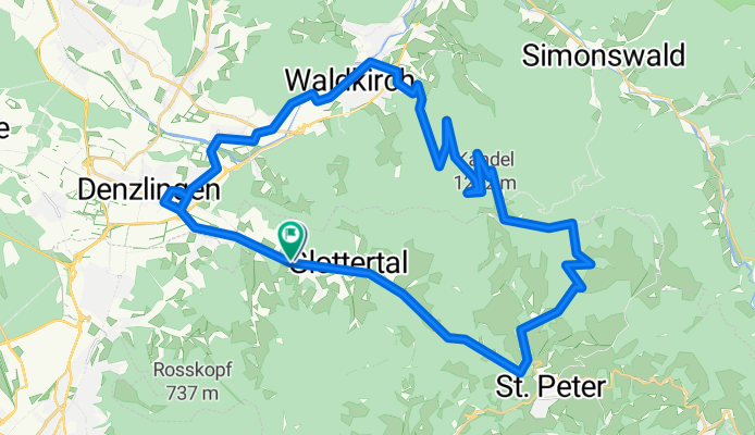
Glottertal-Kandel-Glottertal
A cycling route starting in Glottertal, Baden-Württemberg, Germany.
Overview
About this route
- -:--
- Duration
- 42.1 km
- Distance
- 972 m
- Ascent
- 975 m
- Descent
- ---
- Avg. speed
- ---
- Avg. speed
Route quality
Waytypes & surfaces along the route
Waytypes
Busy road
19.6 km
(47 %)
Road
13.1 km
(31 %)
Surfaces
Paved
37 km
(88 %)
Unpaved
0.5 km
(1 %)
Asphalt
36.3 km
(86 %)
Paving stones
0.7 km
(2 %)
Continue with Bikemap
Use, edit, or download this cycling route
You would like to ride Glottertal-Kandel-Glottertal or customize it for your own trip? Here is what you can do with this Bikemap route:
Free features
- Save this route as favorite or in collections
- Copy & plan your own version of this route
- Sync your route with Garmin or Wahoo
Premium features
Free trial for 3 days, or one-time payment. More about Bikemap Premium.
- Navigate this route on iOS & Android
- Export a GPX / KML file of this route
- Create your custom printout (try it for free)
- Download this route for offline navigation
Discover more Premium features.
Get Bikemap PremiumFrom our community
Other popular routes starting in Glottertal
 BW-Frei-Singel-Trail-Abfahrt Stampfer-ROUTE 458140
- Distance
- 4.6 km
- Ascent
- 473 m
- Descent
- 237 m
- Location
- Glottertal, Baden-Württemberg, Germany
 DE Glottertal - auf den Kandel
- Distance
- 34.6 km
- Ascent
- 896 m
- Descent
- 893 m
- Location
- Glottertal, Baden-Württemberg, Germany
 Kandel-Oberhof-Waldkirch
- Distance
- 10 km
- Ascent
- 49 m
- Descent
- 896 m
- Location
- Glottertal, Baden-Württemberg, Germany
 BW-Frei-Singel-Trail Vogesenblick-ROUTE 458128
- Distance
- 2.2 km
- Ascent
- 0 m
- Descent
- 248 m
- Location
- Glottertal, Baden-Württemberg, Germany
 Kandel-Simonswald-Waldkirch
- Distance
- 18 km
- Ascent
- 130 m
- Descent
- 978 m
- Location
- Glottertal, Baden-Württemberg, Germany
 Kaiserstuhl von Glottertal aus
- Distance
- 94.1 km
- Ascent
- 995 m
- Descent
- 981 m
- Location
- Glottertal, Baden-Württemberg, Germany
 DE Glottertal - Schauinsland und St. Peter
- Distance
- 68.5 km
- Ascent
- 1,289 m
- Descent
- 1,289 m
- Location
- Glottertal, Baden-Württemberg, Germany
 BW-Frei-Thoma-Weg-ROUTE 458121
- Distance
- 10.4 km
- Ascent
- 92 m
- Descent
- 1,067 m
- Location
- Glottertal, Baden-Württemberg, Germany
Open it in the app