

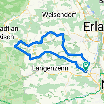
Erlangen-Herzogenaurach
A cycling route starting in Seukendorf, Bavaria, Germany.
Overview
About this route
beiST244(Nordumgehung) auf der Straße bleiben Radweg(links) ende im nichts!
- -:--
- Duration
- 47.3 km
- Distance
- 251 m
- Ascent
- 252 m
- Descent
- ---
- Avg. speed
- ---
- Avg. speed

Route quality
Waytypes & surfaces along the route
Waytypes
Quiet road
17.8 km
(38 %)
Road
14.6 km
(31 %)
Surfaces
Paved
38.3 km
(81 %)
Unpaved
2.1 km
(4 %)
Asphalt
37.5 km
(79 %)
Gravel
2 km
(4 %)
Continue with Bikemap
Use, edit, or download this cycling route
You would like to ride Erlangen-Herzogenaurach or customize it for your own trip? Here is what you can do with this Bikemap route:
Free features
- Save this route as favorite or in collections
- Copy & plan your own version of this route
- Sync your route with Garmin or Wahoo
Premium features
Free trial for 3 days, or one-time payment. More about Bikemap Premium.
- Navigate this route on iOS & Android
- Export a GPX / KML file of this route
- Create your custom printout (try it for free)
- Download this route for offline navigation
Discover more Premium features.
Get Bikemap PremiumFrom our community
Other popular routes starting in Seukendorf
 burgfarrnbach rennhofen und zurück
- Distance
- 56.9 km
- Ascent
- 483 m
- Descent
- 460 m
- Location
- Seukendorf, Bavaria, Germany
 Höhenmeter im westlichen Stadtwald
- Distance
- 15.7 km
- Ascent
- 270 m
- Descent
- 270 m
- Location
- Seukendorf, Bavaria, Germany
 Obermichelbach-Dürrnbuch-Langenzenn
- Distance
- 55.5 km
- Ascent
- 269 m
- Descent
- 269 m
- Location
- Seukendorf, Bavaria, Germany
 PN Rundtour Start+Ende Burgfarrnbach Bahnhof
- Distance
- 18 km
- Ascent
- 191 m
- Descent
- 192 m
- Location
- Seukendorf, Bavaria, Germany
 Training Gelände bisschen Ausdauer
- Distance
- 11.1 km
- Ascent
- 111 m
- Descent
- 113 m
- Location
- Seukendorf, Bavaria, Germany
 Gerade Fahrt in Cadolzburg
- Distance
- 20.2 km
- Ascent
- 103 m
- Descent
- 100 m
- Location
- Seukendorf, Bavaria, Germany
 Rundweg - David
- Distance
- 68.4 km
- Ascent
- 283 m
- Descent
- 283 m
- Location
- Seukendorf, Bavaria, Germany
 Fürther-Stadtwald Audauer-/Techniktraining
- Distance
- 24.2 km
- Ascent
- 339 m
- Descent
- 340 m
- Location
- Seukendorf, Bavaria, Germany
Open it in the app