
Hergiswil Berggasthof Alpgschwänd
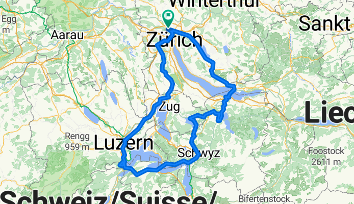
A cycling route starting in Zürich (Kreis 11) / Affoltern, Canton of Zurich, Switzerland.
Overview
About this route
Zürich, Waldegg, Türlersee, Hausen am Albis, Baar/Steinhausen, Cham, Rotkreuz, Luzern, Horw, Hergiswil, hier dem Wegweiser Rest. Brunni /Alpgschwänd folgen, mit der Gondel hoch zum Rest.Alpgschwänd.
Rückfahrt nach freier Wahl od. via Stans,
Beckenried, Autofähre nach Gersau, weiter via Brunnen, Schwyz, Sattel.
Rückfahrt nach freier Wahl od. via Oberägeri, Ratenpass, Einsiedeln, Sankt. Meinhard, Päffikon SZ, Rapperswil.
Rückfahrt n. f. Wahl. . . :-)) !
Viel Spass Stephan
- -:--
- Duration
- 195.4 km
- Distance
- 1,569 m
- Ascent
- 1,569 m
- Descent
- ---
- Avg. speed
- ---
- Avg. speed

Route quality
Waytypes & surfaces along the route
Waytypes
Busy road
103.1 km
(53 %)
Road
33.4 km
(17 %)
Surfaces
Paved
154.7 km
(79 %)
Unpaved
1.1 km
(<1 %)
Asphalt
151 km
(77 %)
Concrete
2.6 km
(1 %)
Continue with Bikemap
Use, edit, or download this cycling route
You would like to ride Hergiswil Berggasthof Alpgschwänd or customize it for your own trip? Here is what you can do with this Bikemap route:
Free features
- Save this route as favorite or in collections
- Copy & plan your own version of this route
- Sync your route with Garmin or Wahoo
Premium features
Free trial for 3 days, or one-time payment. More about Bikemap Premium.
- Navigate this route on iOS & Android
- Export a GPX / KML file of this route
- Create your custom printout (try it for free)
- Download this route for offline navigation
Discover more Premium features.
Get Bikemap PremiumFrom our community
Other popular routes starting in Zürich (Kreis 11) / Affoltern
 Zum Rhein
- Distance
- 80.8 km
- Ascent
- 623 m
- Descent
- 648 m
- Location
- Zürich (Kreis 11) / Affoltern, Canton of Zurich, Switzerland
 Greifensee- Zürichsee- St Meinrad- Kilchberg- Zürich
- Distance
- 106.7 km
- Ascent
- 942 m
- Descent
- 942 m
- Location
- Zürich (Kreis 11) / Affoltern, Canton of Zurich, Switzerland
 Reicht fürs erste Mal
- Distance
- 83.4 km
- Ascent
- 486 m
- Descent
- 487 m
- Location
- Zürich (Kreis 11) / Affoltern, Canton of Zurich, Switzerland
 Rheinfall
- Distance
- 83.9 km
- Ascent
- 744 m
- Descent
- 744 m
- Location
- Zürich (Kreis 11) / Affoltern, Canton of Zurich, Switzerland
 Bergtraining!
- Distance
- 92.2 km
- Ascent
- 1,651 m
- Descent
- 1,674 m
- Location
- Zürich (Kreis 11) / Affoltern, Canton of Zurich, Switzerland
 Glaziallandschaft Katzenseen ohne Schlaufen
- Distance
- 14.3 km
- Ascent
- 182 m
- Descent
- 196 m
- Location
- Zürich (Kreis 11) / Affoltern, Canton of Zurich, Switzerland
 Sihlbrugg-Gottschalkenberg
- Distance
- 91.7 km
- Ascent
- 829 m
- Descent
- 829 m
- Location
- Zürich (Kreis 11) / Affoltern, Canton of Zurich, Switzerland
 um den Züri-See
- Distance
- 113.3 km
- Ascent
- 558 m
- Descent
- 598 m
- Location
- Zürich (Kreis 11) / Affoltern, Canton of Zurich, Switzerland
Open it in the app