<div class="MsoNormal" style="color: #000000; font-family: Helvetica; font-size: medium;"><span style="font-family: Arial;">As there was heavy rain at night and we were greeted by an overcast morning of clouds and cold wind, we slept late and had a leisurely breakfast before going out, being unsure whether we’d be dumped on.<span> </span>Fortunately, although we had to deal with cold winds (really only an issue on the descents), we didn’t get rained on.<span> </span>Subsequent to the ride, we heard that the weather would be better tomorrow.<span> </span>And consistent with that news, we did have some sun for about the last hour of our ride.</span></div>
<div class="MsoNormal" style="color: #000000; font-family: Helvetica; font-size: medium;"><span style="font-family: Arial;">
<div class="MsoNormal">
<div class="MsoNormal">
<div class="MsoNormal"><span style="font-family: Arial;"> </span></div>
<div class="MsoNormal"><span style="font-family: Arial;">This area is outstanding in beauty, but because it draws lots of tourists and there are many summer chalets, there’s generally too much traffic.<span> </span>If we come this way again, it should be sometime other than July and August.</span></div>
<div class="MsoNormal"><br /></div>
<div class="MsoNormal"><span style="font-family: Arial;"> </span></div>
<div class="MsoNormal"><span style="font-family: Arial;">The route was all great riding; just too many cars in some of it.</span></div>
<div class="MsoNormal"><span style="font-family: Arial;"> </span></div>
<div class="MsoNormal"><br /></div>
<div class="MsoNormal"><span style="font-family: Arial;">La Bresse was in a narrow valley with relatively steep sides.<span> </span>We descended down the east side and climbed out the west side.<span> </span>The Westside was filled with chalets.</span></div>
<div class="MsoNormal"><br /></div>
</div>
<div class="MsoNormal"><span style="font-family: Arial;"> </span></div>
<div class="MsoNormal">During the day, we started and ended in the Vosges Department within the Lorraine Region, but did ride into the Haut-Rhin Department in the Alsace Region.</div>
</div>
<div class="MsoNormal"><br /></div>
<div class="MsoNormal">Route:</div>
<div class="MsoNormal"><br /></div>
</span><span style="font-family: Arial;">
<div class="MsoNormal">
<div class="MsoNormal"><span style="font-family: Arial;">
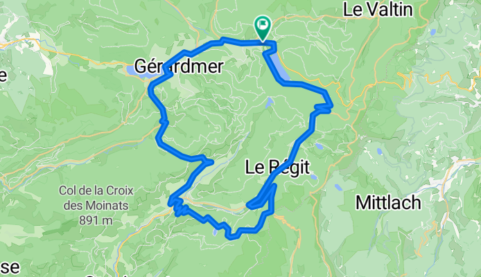
<span style="font-family: Arial;">D67 to road around south side of Lac de Langemer and by Lac de Returnemer Southeast to</span>
<span style="font-family: Arial;">D34D at La Lode de Feignes (a little over 900 M) Southwest past Col des Feignes (954 M) to</span>
<span style="font-family: Arial;">D34 East to Col de Bramont (956 M)</span>
<span style="font-family: Arial;">Unnumbered roads West past Col de la Vierge (1066 M) to La Bresse</span>
<span style="font-family: Arial;">D486 North from La Bresse past Col de Grosse Pierre (955 M) and Col du Haut de la Côte (799 M) to Gérardmer</span>
<span style="font-family: Arial;">D417 Northeast to Xonrupt-Longemer and hotel</span>
</span></div>
</div>
<div class="MsoNormal">
<div class="MsoNormal">
<div class="MsoNormal"></div>
</div>
</div>
</span><span style="font-family: Arial;">
<div class="MsoNormal">
<div class="MsoNormal">
<div class="MsoNormal"></div>
</div>
<div class="MsoNormal"><br /></div>
</div>
</span></div>
<div class="MsoNormal" style="color: #000000; font-family: Helvetica; font-size: medium;">
Background:<span style="font-family: Arial;">
<div class="MsoNormal" style="font-size: 16px;"><span style="font-family: Arial;"> </span></div>
</span></div>
My wife and I have been doing self-supported tours in Western Europe (a majority in France) since 1993. This series of rides covers our 2009 4.5 month route through parts of France, Germany, Austria, Switzerland, and then back to France. Our beginning and ending point is near Chadurie (south of Angouleme) where our friends have a farm with Gites and Chambres d'Hotes.
We rode our Dawes touring bicycles purchased in 1993 heavily loaded with 700Cx32 tires. All of our riding was on paved roads, mostly with very little traffic. Pretty much the only unpaved sections were some bicycle paths in Germany and Austria. Sadly, that wasn't so great as Helen fell a number of times on the unpaved paths. Fortunately, though, no serious injury.
If any questions, feel free to email me at jeffkadet@netdiving.com
Jeff