

2012一日雙北
A cycling route starting in Banqiao District, Taipei, Taiwan.
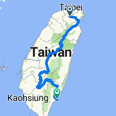
Overview
About this route
19T第一次的一日雙北活動,採較簡單的西進北橫,東上北宜路線進行。
0K 碧潭大橋7-11(天闊門市)台北集合點
19K 三峽分局7-11(天下門市)三鶯集合點
41K 角板山萊爾富休息
71K 巴陵大橋集結
72K 巴陵休息
75K 大漢橋照相
83K 四陵大漢守衛站照相
91K 明池休息
101K 北橫777路牌照相
110K 北橫蘭陽溪路口集結
136K 員山香草菲菲午餐
155K 礁溪火車站7-11(永裕門市)補給
170K 石牌縣界公園集結
189K 坪林7-11休息
200K 小格頭海崙咖啡集結
216K 捷運新店站結束
- -:--
- Duration
- 215.7 km
- Distance
- 2,530 m
- Ascent
- 2,536 m
- Descent
- ---
- Avg. speed
- ---
- Avg. speed

Route quality
Waytypes & surfaces along the route
Waytypes
Busy road
170.2 km
(79 %)
Quiet road
18.4 km
(9 %)
Surfaces
Paved
75.5 km
(35 %)
Unpaved
1.4 km
(<1 %)
Asphalt
75.5 km
(35 %)
Unpaved (undefined)
1.4 km
(<1 %)
Undefined
138.7 km
(64 %)
Route highlights
Points of interest along the route
Drinking water after 19.9 km
7-11天下門市
Drinking water after 40.7 km
角板山萊爾富
Point of interest after 71.4 km
巴陵大橋
Point of interest after 82.9 km
四陵
Point of interest after 90.9 km
明池
Point of interest after 136.6 km
員山香草菲菲
Drinking water after 154.5 km
礁溪火車站
Point of interest after 169.9 km
石牌縣界公園
Drinking water after 188.7 km
坪林7-11
Point of interest after 200.2 km
小格頭海倫咖啡
Continue with Bikemap
Use, edit, or download this cycling route
You would like to ride 2012一日雙北 or customize it for your own trip? Here is what you can do with this Bikemap route:
Free features
- Save this route as favorite or in collections
- Copy & plan your own version of this route
- Sync your route with Garmin or Wahoo
Premium features
Free trial for 3 days, or one-time payment. More about Bikemap Premium.
- Navigate this route on iOS & Android
- Export a GPX / KML file of this route
- Create your custom printout (try it for free)
- Download this route for offline navigation
Discover more Premium features.
Get Bikemap PremiumFrom our community
Other popular routes starting in Banqiao District
 北42/北43"藍鵲"公路
- Distance
- 90 km
- Ascent
- 1,049 m
- Descent
- 1,042 m
- Location
- Banqiao District, Taipei, Taiwan
 縣106號操兵_中和至平溪
- Distance
- 29.9 km
- Ascent
- 446 m
- Descent
- 230 m
- Location
- Banqiao District, Taipei, Taiwan
 烏來老街 ↔ 福山
- Distance
- 17 km
- Ascent
- 750 m
- Descent
- 479 m
- Location
- Banqiao District, Taipei, Taiwan
 一日北高
一日北高- Distance
- 362.1 km
- Ascent
- 310 m
- Descent
- 313 m
- Location
- Banqiao District, Taipei, Taiwan
 新店_(台9)坪林_106乙(石碇)_環圈
- Distance
- 59.8 km
- Ascent
- 2,096 m
- Descent
- 2,095 m
- Location
- Banqiao District, Taipei, Taiwan
 永和-深坑-石碇106乙-北47-北宜-新店
- Distance
- 48.2 km
- Ascent
- 541 m
- Descent
- 541 m
- Location
- Banqiao District, Taipei, Taiwan
 中和-三芝櫻花道-北投-中和
- Distance
- 87.8 km
- Ascent
- 721 m
- Descent
- 721 m
- Location
- Banqiao District, Taipei, Taiwan
 中央山脈一條鞭
- Distance
- 690.1 km
- Ascent
- 8,446 m
- Descent
- 8,466 m
- Location
- Banqiao District, Taipei, Taiwan
Open it in the app