

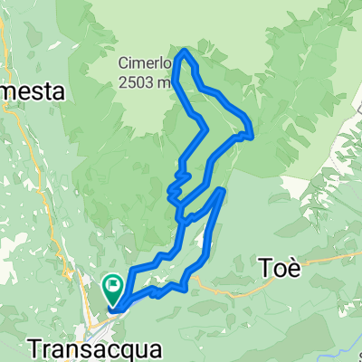
Tonadico, Val Belluna, Valle del MIs
A cycling route starting in Tonadico, Trentino-Alto Adige, Italy.
Overview
About this route
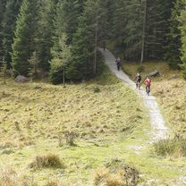
<span style="color: #eeeeee; font-family: sans-serif, helvetica; font-size: 13px; background-color: #000000;">During the tour the cyclist can watch some different landscapes: from the deep canyons of the Schener and the Mis valley to the nice villages of the Belluna valley and the houses in the middle of nowhere around Gosaldo.</span>
- -:--
- Duration
- 100.8 km
- Distance
- 1,558 m
- Ascent
- 1,528 m
- Descent
- ---
- Avg. speed
- ---
- Avg. speed
Continue with Bikemap
Use, edit, or download this cycling route
You would like to ride Tonadico, Val Belluna, Valle del MIs or customize it for your own trip? Here is what you can do with this Bikemap route:
Free features
- Save this route as favorite or in collections
- Copy & plan your own version of this route
- Sync your route with Garmin or Wahoo
Premium features
Free trial for 3 days, or one-time payment. More about Bikemap Premium.
- Navigate this route on iOS & Android
- Export a GPX / KML file of this route
- Create your custom printout (try it for free)
- Download this route for offline navigation
Discover more Premium features.
Get Bikemap PremiumFrom our community
Other popular routes starting in Tonadico
 LiAn24_8
- Distance
- 66 km
- Ascent
- 1,892 m
- Descent
- 2,697 m
- Location
- Tonadico, Trentino-Alto Adige, Italy
 Mytos by Panther 3
- Distance
- 48.8 km
- Ascent
- 2,036 m
- Descent
- 2,038 m
- Location
- Tonadico, Trentino-Alto Adige, Italy
 Tonadico, Val Belluna, Valle del MIs
- Distance
- 100.8 km
- Ascent
- 1,558 m
- Descent
- 1,528 m
- Location
- Tonadico, Trentino-Alto Adige, Italy
 Tonadico, Tognola, Forcella Val Sorda, Zortea, Tonadico
- Distance
- 46.8 km
- Ascent
- 1,874 m
- Descent
- 1,874 m
- Location
- Tonadico, Trentino-Alto Adige, Italy
 lago di calaita mtb
- Distance
- 28.2 km
- Ascent
- 984 m
- Descent
- 984 m
- Location
- Tonadico, Trentino-Alto Adige, Italy
 val canali da tonadico mtb
- Distance
- 22.2 km
- Ascent
- 967 m
- Descent
- 967 m
- Location
- Tonadico, Trentino-Alto Adige, Italy
 19 etapa Giro
- Distance
- 97.2 km
- Ascent
- 2,528 m
- Descent
- 2,529 m
- Location
- Tonadico, Trentino-Alto Adige, Italy
 Tour of Vette Feltrine
- Distance
- 80.2 km
- Ascent
- 2,978 m
- Descent
- 2,978 m
- Location
- Tonadico, Trentino-Alto Adige, Italy
Open it in the app