
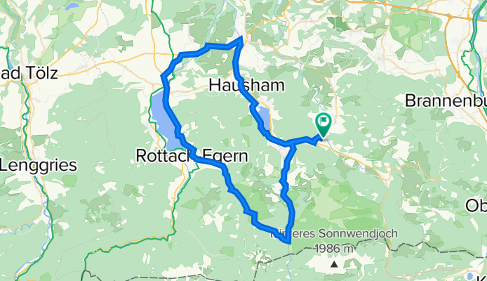
Aurach - Schliersee - Tegernsee - Spitzingsee
A cycling route starting in Fischbachau, Bavaria, Germany.
Overview
About this route
3-Seen-Tour von Aurach über Schliersee vorbei abseits der Hauptstrasse nach Haushamm/Miesbach. Von Miesbach aus Richtung Bad Tölz für ca. 5km. Hier sind ca. 2-3 km an der Hauptstrasse zu fahren, danach links abbiegen Richtung Gmund/Tegernsee. Weiter Richtung Rotach-Egern und danach links ab Richtung Valepp. Hier beginnt der schönste und steilste Teil der Rundfahrt über die Moni-Alm Richtung Valepp und Spitzingsee. Ist der Spitzingsee/Spitzingsattel erreicht, kann man sich auf eine ca. 5km lange Abfahrt freuen und den Rest nach Aurach ausrollen lassen.
- -:--
- Duration
- 63.3 km
- Distance
- 787 m
- Ascent
- 787 m
- Descent
- ---
- Avg. speed
- ---
- Avg. speed
Route quality
Waytypes & surfaces along the route
Waytypes
Busy road
29.6 km
(47 %)
Quiet road
20.9 km
(33 %)
Surfaces
Paved
60.9 km
(96 %)
Unpaved
0.2 km
(<1 %)
Asphalt
60.4 km
(95 %)
Paving stones
0.3 km
(<1 %)
Continue with Bikemap
Use, edit, or download this cycling route
You would like to ride Aurach - Schliersee - Tegernsee - Spitzingsee or customize it for your own trip? Here is what you can do with this Bikemap route:
Free features
- Save this route as favorite or in collections
- Copy & plan your own version of this route
- Sync your route with Garmin or Wahoo
Premium features
Free trial for 3 days, or one-time payment. More about Bikemap Premium.
- Navigate this route on iOS & Android
- Export a GPX / KML file of this route
- Create your custom printout (try it for free)
- Download this route for offline navigation
Discover more Premium features.
Get Bikemap PremiumFrom our community
Other popular routes starting in Fischbachau
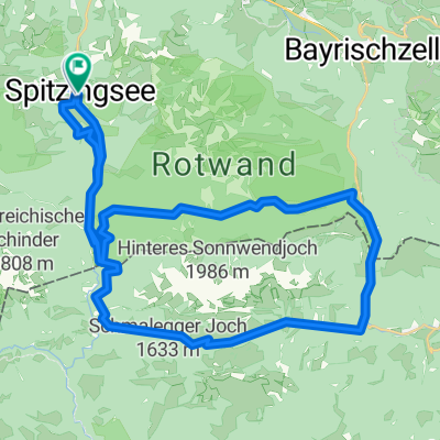
 vom Spitzingsee - ums ht. Sonnwendjoch - über den Elendsattel
- Distance
- 43.9 km
- Ascent
- 1,387 m
- Descent
- 1,488 m
- Location
- Fischbachau, Bavaria, Germany
 vom Spitzingsee - ums ht. Sonnwendjoch - über den Elendsattel
- Distance
- 44 km
- Ascent
- 1,083 m
- Descent
- 1,094 m
- Location
- Fischbachau, Bavaria, Germany
 Leitzachtaler Bergblickweg
- Distance
- 12.2 km
- Ascent
- 198 m
- Descent
- 176 m
- Location
- Fischbachau, Bavaria, Germany
 Schliersee-Tegernsee
- Distance
- 52.8 km
- Ascent
- 961 m
- Descent
- 1,212 m
- Location
- Fischbachau, Bavaria, Germany
 Rund um den Schweinsberg
- Distance
- 10.2 km
- Ascent
- 861 m
- Descent
- 861 m
- Location
- Fischbachau, Bavaria, Germany
 Übern Spitzingsattel zur Oberen Schönfeldalm
- Distance
- 19.6 km
- Ascent
- 870 m
- Descent
- 844 m
- Location
- Fischbachau, Bavaria, Germany
 Von Neuhaus über den Soinsee zum Rotwandhaus
- Distance
- 29.4 km
- Ascent
- 1,059 m
- Descent
- 1,059 m
- Location
- Fischbachau, Bavaria, Germany
 Rund um die Rotwand (ab/bis Neuhaus)
- Distance
- 40.4 km
- Ascent
- 1,004 m
- Descent
- 1,004 m
- Location
- Fischbachau, Bavaria, Germany
Open it in the app