

Schorndorf, Schurwald, Kaiserberge, Welzheimer Wald, Berglen, Schorndorf
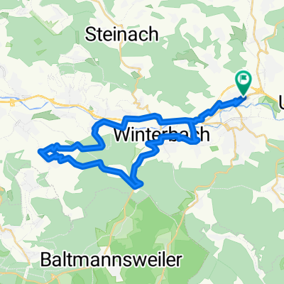
A cycling route starting in Schorndorf, Baden-Württemberg, Germany.
Overview
About this route
Bei der Streckenauswahl standen 3 Dinge im Vordergrund: kleine Straßen, schöne Landschaft und nicht zuletzt: keine Steigung auslassen. Entsprechend empfiehlt es sich, diese Tour mit einer kleinen Übersetzung (max. 39/26) in Angriff zu nehmen, da die Steigung häufig die 10% übersteigt und gelegentlich auch in Richtung 20% (beide Anstiege zum Hohenstaufen) geht.
- -:--
- Duration
- 115.6 km
- Distance
- 2,302 m
- Ascent
- 2,261 m
- Descent
- ---
- Avg. speed
- 617 m
- Avg. speed
Route quality
Waytypes & surfaces along the route
Waytypes
Road
54.6 km
(47 %)
Quiet road
31 km
(27 %)
Surfaces
Paved
102 km
(88 %)
Unpaved
0.3 km
(<1 %)
Asphalt
100.1 km
(87 %)
Paved (undefined)
1.8 km
(2 %)
Continue with Bikemap
Use, edit, or download this cycling route
You would like to ride Schorndorf, Schurwald, Kaiserberge, Welzheimer Wald, Berglen, Schorndorf or customize it for your own trip? Here is what you can do with this Bikemap route:
Free features
- Save this route as favorite or in collections
- Copy & plan your own version of this route
- Sync your route with Garmin or Wahoo
Premium features
Free trial for 3 days, or one-time payment. More about Bikemap Premium.
- Navigate this route on iOS & Android
- Export a GPX / KML file of this route
- Create your custom printout (try it for free)
- Download this route for offline navigation
Discover more Premium features.
Get Bikemap PremiumFrom our community
Other popular routes starting in Schorndorf
 Schdf-Schlbach-Lindental-Buhlbronn-Schdf
- Distance
- 24.2 km
- Ascent
- 282 m
- Descent
- 282 m
- Location
- Schorndorf, Baden-Württemberg, Germany
 Schorndorf - Trinkwasser - Schönbühl
- Distance
- 32.5 km
- Ascent
- 475 m
- Descent
- 476 m
- Location
- Schorndorf, Baden-Württemberg, Germany
 Schorndorf-Berglen-Gmünd
- Distance
- 80.9 km
- Ascent
- 884 m
- Descent
- 883 m
- Location
- Schorndorf, Baden-Württemberg, Germany
 Schorndorf - Winnenden
- Distance
- 24.5 km
- Ascent
- 155 m
- Descent
- 120 m
- Location
- Schorndorf, Baden-Württemberg, Germany
 Rund um Schorndorf
- Distance
- 54.2 km
- Ascent
- 948 m
- Descent
- 976 m
- Location
- Schorndorf, Baden-Württemberg, Germany
 Von Schorndorf bis Stuttgart
- Distance
- 46.4 km
- Ascent
- 235 m
- Descent
- 252 m
- Location
- Schorndorf, Baden-Württemberg, Germany
 Schorndorf-Bärensee
- Distance
- 34.3 km
- Ascent
- 738 m
- Descent
- 601 m
- Location
- Schorndorf, Baden-Württemberg, Germany
 Schdf-Schnait-Weinstadt-Schdf
- Distance
- 30.8 km
- Ascent
- 450 m
- Descent
- 453 m
- Location
- Schorndorf, Baden-Württemberg, Germany
Open it in the app