
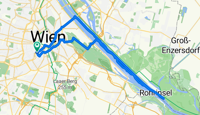
Naschmarkt, Prater, Donauinsel bis Reichsbrücke
A cycling route starting in Vienna, Vienna, Austria.
Overview
About this route
Vom Naschmarkt über den Radweg Margaretenstraße, Gußhausstraße über Schwarzenbergplatz und Heumarkt, rechts in die Beatrixgasse gegen die Einbahn bis Löwengasse, über Rasumofskygasse in den Prater. Rotundenallee und Hauptallee bis zur Südosttangente, hinüber zur Donauinsel. Dort bis zur Südspitze, dann am Endlastungsgerinne bis zur Reichsbrücke und über Praterstern, Ring und Wienzeile zurück.
- -:--
- Duration
- 36.2 km
- Distance
- 107 m
- Ascent
- 108 m
- Descent
- ---
- Avg. speed
- ---
- Avg. speed
Route quality
Waytypes & surfaces along the route
Waytypes
Cycleway
27.5 km
(76 %)
Access road
4.1 km
(11 %)
Surfaces
Paved
33.6 km
(93 %)
Asphalt
32.5 km
(90 %)
Paving stones
0.7 km
(2 %)
Continue with Bikemap
Use, edit, or download this cycling route
You would like to ride Naschmarkt, Prater, Donauinsel bis Reichsbrücke or customize it for your own trip? Here is what you can do with this Bikemap route:
Free features
- Save this route as favorite or in collections
- Copy & plan your own version of this route
- Sync your route with Garmin or Wahoo
Premium features
Free trial for 3 days, or one-time payment. More about Bikemap Premium.
- Navigate this route on iOS & Android
- Export a GPX / KML file of this route
- Create your custom printout (try it for free)
- Download this route for offline navigation
Discover more Premium features.
Get Bikemap PremiumFrom our community
Other popular routes starting in Vienna
 Augustiner- u Mostalmtrail über Sophienalpe
- Distance
- 32.1 km
- Ascent
- 540 m
- Descent
- 534 m
- Location
- Vienna, Vienna, Austria
 Donau-Radweg: Wien-Bratislava
- Distance
- 70.9 km
- Ascent
- 332 m
- Descent
- 340 m
- Location
- Vienna, Vienna, Austria
 Tag 3 LUFLA Tour 2025 Wien nach Bratislava
- Distance
- 91 km
- Ascent
- 398 m
- Descent
- 458 m
- Location
- Vienna, Vienna, Austria
 Wien - Neusiedl am See (La Primavera Austria)
- Distance
- 116.4 km
- Ascent
- 287 m
- Descent
- 287 m
- Location
- Vienna, Vienna, Austria
 Wien - Haslau an der Donau - Kittsee - Wien
- Distance
- 138.3 km
- Ascent
- 371 m
- Descent
- 423 m
- Location
- Vienna, Vienna, Austria
 Boku-Exelberg-Sophie-Riederb-TulbingK-Königstetten-St-Andrae-Hintersd-Boku
- Distance
- 84.2 km
- Ascent
- 1,189 m
- Descent
- 1,189 m
- Location
- Vienna, Vienna, Austria
 Eduard-Sueß-Gasse 24–30, Wien nach Eduard-Sueß-Gasse 26, Wien
- Distance
- 38.8 km
- Ascent
- 194 m
- Descent
- 191 m
- Location
- Vienna, Vienna, Austria
 After_Work_Training_Standard
- Distance
- 69.7 km
- Ascent
- 1,149 m
- Descent
- 1,084 m
- Location
- Vienna, Vienna, Austria
Open it in the app