
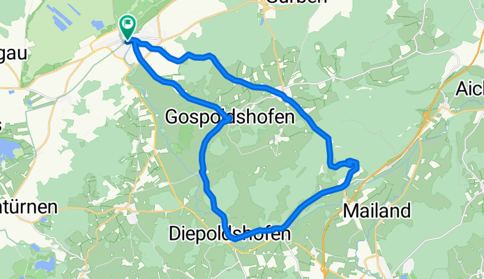
Bad Wurzach - Schloß Zeil
A cycling route starting in Bad Wurzach, Baden-Württemberg, Germany.
Overview
About this route
Bad Wurzach -> Gospoldshofen -> Diepoldshofen -> Reichenhofen -> Unterzei -> Schloß Zeil -> Seibranz -> Metzesweiler -> Bad Wurzach
- -:--
- Duration
- 27.1 km
- Distance
- 388 m
- Ascent
- 364 m
- Descent
- ---
- Avg. speed
- 776 m
- Avg. speed
Route quality
Waytypes & surfaces along the route
Waytypes
Quiet road
9.7 km
(36 %)
Road
8.4 km
(31 %)
Surfaces
Paved
24.3 km
(90 %)
Unpaved
1.5 km
(6 %)
Asphalt
21.1 km
(78 %)
Paved (undefined)
3.1 km
(12 %)
Route highlights
Points of interest along the route
Point of interest after 17.1 km
Schloß Zeil
Continue with Bikemap
Use, edit, or download this cycling route
You would like to ride Bad Wurzach - Schloß Zeil or customize it for your own trip? Here is what you can do with this Bikemap route:
Free features
- Save this route as favorite or in collections
- Copy & plan your own version of this route
- Sync your route with Garmin or Wahoo
Premium features
Free trial for 3 days, or one-time payment. More about Bikemap Premium.
- Navigate this route on iOS & Android
- Export a GPX / KML file of this route
- Create your custom printout (try it for free)
- Download this route for offline navigation
Discover more Premium features.
Get Bikemap PremiumFrom our community
Other popular routes starting in Bad Wurzach
 WurzacherRied_up
- Distance
- 49.2 km
- Ascent
- 336 m
- Descent
- 340 m
- Location
- Bad Wurzach, Baden-Württemberg, Germany
 Tour ins Allgäu
- Distance
- 91 km
- Ascent
- 1,050 m
- Descent
- 1,010 m
- Location
- Bad Wurzach, Baden-Württemberg, Germany
 Bellamot
- Distance
- 45.3 km
- Ascent
- 302 m
- Descent
- 307 m
- Location
- Bad Wurzach, Baden-Württemberg, Germany
 Runde ums Haus Et.V (Wolfegg-Rot a.d.Rot)
- Distance
- 75.5 km
- Ascent
- 520 m
- Descent
- 515 m
- Location
- Bad Wurzach, Baden-Württemberg, Germany
 Illerbeuren
- Distance
- 61 km
- Ascent
- 425 m
- Descent
- 418 m
- Location
- Bad Wurzach, Baden-Württemberg, Germany
 All5: Haidgau - Wangen; 64,1km 640hm
- Distance
- 64.1 km
- Ascent
- 802 m
- Descent
- 903 m
- Location
- Bad Wurzach, Baden-Württemberg, Germany
 20km
20km- Distance
- 19.8 km
- Ascent
- 193 m
- Descent
- 197 m
- Location
- Bad Wurzach, Baden-Württemberg, Germany
 Bad Wurzach -> Wollfegg -> Bad Waldsee
- Distance
- 55.9 km
- Ascent
- 325 m
- Descent
- 325 m
- Location
- Bad Wurzach, Baden-Württemberg, Germany