

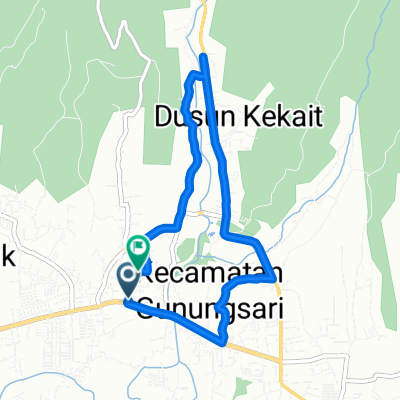
Lombok- Matarm to Gunungsari-Bukit Kedondong-Senggigi
A cycling route starting in Mambalan, West Nusa Tenggara, Indonesia.
Overview
About this route
Short ride uphill through West Lombok countryside. Fabuluous view of Selaparang Mataram area followed by a sea view of Senggigi area. Brutal uphill singletracks and downhill to sunset beach.
Actually riden on mountainbike Aug 2012
- -:--
- Duration
- 13.1 km
- Distance
- 476 m
- Ascent
- 497 m
- Descent
- ---
- Avg. speed
- ---
- Max. altitude

Route quality
Waytypes & surfaces along the route
Waytypes
Road
10.5 km
(80 %)
Quiet road
1.2 km
(9 %)
Surfaces
Paved
8.9 km
(68 %)
Unpaved
3.9 km
(30 %)
Asphalt
6.4 km
(49 %)
Gravel
3.9 km
(30 %)
Continue with Bikemap
Use, edit, or download this cycling route
You would like to ride Lombok- Matarm to Gunungsari-Bukit Kedondong-Senggigi or customize it for your own trip? Here is what you can do with this Bikemap route:
Free features
- Save this route as favorite or in collections
- Copy & plan your own version of this route
- Sync your route with Garmin or Wahoo
Premium features
Free trial for 3 days, or one-time payment. More about Bikemap Premium.
- Navigate this route on iOS & Android
- Export a GPX / KML file of this route
- Create your custom printout (try it for free)
- Download this route for offline navigation
Discover more Premium features.
Get Bikemap PremiumFrom our community
Other popular routes starting in Mambalan
 L-6 to L-6
- Distance
- 8.1 km
- Ascent
- 43 m
- Descent
- 84 m
- Location
- Mambalan, West Nusa Tenggara, Indonesia
 Jalan Raya Meninting, Kecamatan Batu Layar to H2JX+3QV, Kecamatan Pemenang
- Distance
- 21.8 km
- Ascent
- 339 m
- Descent
- 340 m
- Location
- Mambalan, West Nusa Tenggara, Indonesia
 Jalan Pariwisata 40, Gunung Sari to Jalan Pariwisata 32, Gunung Sari
- Distance
- 9.9 km
- Ascent
- 87 m
- Descent
- 91 m
- Location
- Mambalan, West Nusa Tenggara, Indonesia
 Bukit cacing
- Distance
- 42.5 km
- Ascent
- 7 m
- Descent
- 0 m
- Location
- Mambalan, West Nusa Tenggara, Indonesia
 meninting batu layar
- Distance
- 7.1 km
- Ascent
- 70 m
- Descent
- 75 m
- Location
- Mambalan, West Nusa Tenggara, Indonesia
 Lombok- Matarm to Gunungsari-Bukit Kedondong-Senggigi
- Distance
- 13.1 km
- Ascent
- 476 m
- Descent
- 497 m
- Location
- Mambalan, West Nusa Tenggara, Indonesia
 L-6 to L-6
- Distance
- 3.6 km
- Ascent
- 18 m
- Descent
- 58 m
- Location
- Mambalan, West Nusa Tenggara, Indonesia
 15 + 1 peaks plus a monkey forest
- Distance
- 54 km
- Ascent
- 528 m
- Descent
- 528 m
- Location
- Mambalan, West Nusa Tenggara, Indonesia
Open it in the app