Premium Badge Download on the App Store Get it on Google Play Turn-by-turn Navigation Offline Maps Bike Type Optimized Routing Premium Maps Custom Bike Computer Export Routes Route Previews Fall Detection Premium Support

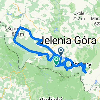
Cycling Route in Podgórzyn, Lower Silesian Voivodeship, Poland

vrbatova bouda - (cerna hora) - (praszka bouda) - lucni bouda - spindlerova bouda

0
Open this route in the Bikemap app

Open this route in the Bikemap app

Open this route in Bikemap Web

Open this route in Bikemap Web

181 km
Distance
4274 m
Ascent
4591 m
Descent
-:-- h
Duration
-- km/h
Avg. Speed
1401 m
Max. Elevation

About This Route

OHNE OPTION CERNA HORA AB JANSKA LAZNE UND PRASZKA BOUDA AB PEC NUR 164KM UND 4100HM


1.PAUSE IN JANSKE LAZNE NACH 116KM

(BZW. 104KM OHNE CERNA HORA!)

2.PAUSE LUCNI BOUDA NACH 145KM

(BZW. 127KM OHNE PRASZKA BOUDA)


GIPFEL VRBATOVA BOUDA NACH 53KM

GIPFEL CERNA HORA NACH 110KM


This cycling route is ideal for: Road bike

You will cycle on the following surfaces: Paved

Customize this cycling route with the Bikemap route planner.

Make it yours!

Did you know? You can use this route as a template in our cycling route planner if you don't wish to start from scratch. Customize it based on your needs to plan your perfect cycling tour.

Open it in the app