

Alle Wege führen nach Templin
A cycling route starting in Glienicke, Brandenburg, Germany.
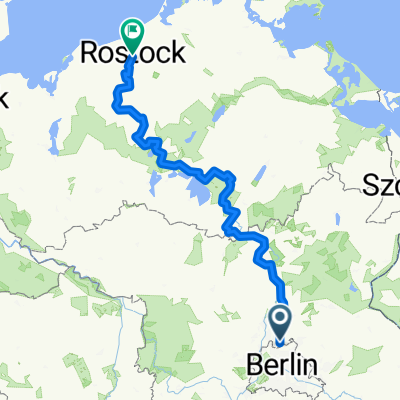
Overview
About this route
-
ab Mühlenbeck: L21->B109 - 60km
-
ab Buchholz: B109->L100->L216 - 70km
-
ab Bernau: L31->L100->L216 - 60km
- -:--
- Duration
- 204.6 km
- Distance
- 437 m
- Ascent
- 431 m
- Descent
- ---
- Avg. speed
- 94 m
- Avg. speed
Route quality
Waytypes & surfaces along the route
Waytypes
Busy road
110 km
(54 %)
Path
39.3 km
(19 %)
Surfaces
Paved
182.4 km
(89 %)
Unpaved
7.1 km
(3 %)
Asphalt
131 km
(64 %)
Paving stones
48 km
(23 %)
Continue with Bikemap
Use, edit, or download this cycling route
You would like to ride Alle Wege führen nach Templin or customize it for your own trip? Here is what you can do with this Bikemap route:
Free features
- Save this route as favorite or in collections
- Copy & plan your own version of this route
- Sync your route with Garmin or Wahoo
Premium features
Free trial for 3 days, or one-time payment. More about Bikemap Premium.
- Navigate this route on iOS & Android
- Export a GPX / KML file of this route
- Create your custom printout (try it for free)
- Download this route for offline navigation
Discover more Premium features.
Get Bikemap PremiumFrom our community
Other popular routes starting in Glienicke
 Route zum Tobi
- Distance
- 12 km
- Ascent
- 57 m
- Descent
- 42 m
- Location
- Glienicke, Brandenburg, Germany
 Glienicke/Nb - Niederheide ca. 25km
- Distance
- 24 km
- Ascent
- 70 m
- Descent
- 69 m
- Location
- Glienicke, Brandenburg, Germany
 Hermsdorf MV Schildow Lübars 18
- Distance
- 17.8 km
- Ascent
- 98 m
- Descent
- 101 m
- Location
- Glienicke, Brandenburg, Germany
 Ostsee
- Distance
- 308.7 km
- Ascent
- 300 m
- Descent
- 332 m
- Location
- Glienicke, Brandenburg, Germany
 Glienicke-Summt-Zehlendorf-Lanke-Bernau-Schönwalde-Glienicke CLONED FROM ROUTE 135352
- Distance
- 61.3 km
- Ascent
- 135 m
- Descent
- 131 m
- Location
- Glienicke, Brandenburg, Germany
 Route nach Mühlenbecker Land
- Distance
- 25.8 km
- Ascent
- 131 m
- Descent
- 130 m
- Location
- Glienicke, Brandenburg, Germany
 Glienicke-Summt-Zehlendorf-Lanke-Bernau-Schönwalde-Glienicke
- Distance
- 61.3 km
- Ascent
- 186 m
- Descent
- 172 m
- Location
- Glienicke, Brandenburg, Germany
 Hochzeitstour v2
- Distance
- 85 km
- Ascent
- 135 m
- Descent
- 135 m
- Location
- Glienicke, Brandenburg, Germany