Premium Badge Download on the App Store Get it on Google Play Turn-by-turn Navigation Offline Maps Bike Type Optimized Routing Premium Maps Custom Bike Computer Export Routes Route Previews Fall Detection Premium Support

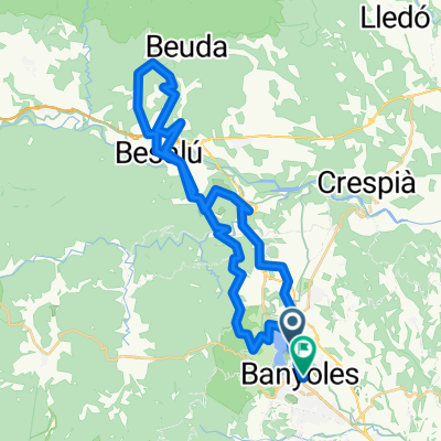
Cycling Route in Banyoles, Catalonia, Spain

Banyoles - Monestir de Montserrat

0
Open this route in the Bikemap app

Open this route in the Bikemap app

Open this route in Bikemap Web

Open this route in Bikemap Web

165 km
Distance
2037 m
Ascent
1513 m
Descent
-:-- h
Duration
-- km/h
Avg. Speed
--- m
Max. Elevation

About This Route

Banyoles -Girona- Anglès-Osor-Sant Hilari Sacalm-Pla de les Arenes-Coll de Revell-Viladrau-Seva-Tona-Coll de la Pollosa-Collsuspina-Moià-Manresa-Monistrol de Montserrat-Monestir de Montserrat.

<div>Recorregut: 160 km<br />Desnivell acumulat: 2.500 m<br />Observacions: Molta atenció al pas de les poblacions i en particular de la carretera de Manresa a Monistrol, així coma a la pujada final al Monestir.</div>

This cycling route is ideal for: Road bike

You will cycle on the following surfaces: Paved

Customize this cycling route with the Bikemap route planner.

Make it yours!

Did you know? You can use this route as a template in our cycling route planner if you don't wish to start from scratch. Customize it based on your needs to plan your perfect cycling tour.

Open it in the app