
hkjhk
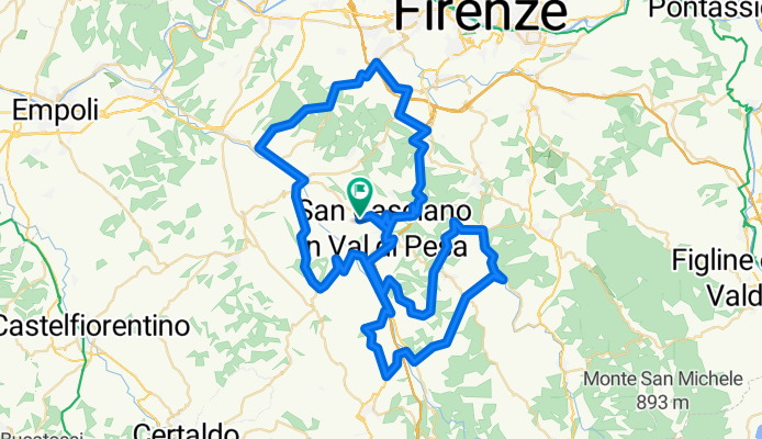
A cycling route starting in San Casciano in Val di Pesa, Tuscany, Italy.
Overview
About this route
- -:--
- Duration
- 94.6 km
- Distance
- 1,350 m
- Ascent
- 1,350 m
- Descent
- ---
- Avg. speed
- ---
- Avg. speed
Route quality
Waytypes & surfaces along the route
Waytypes
Busy road
49.6 km
(52 %)
Road
24.3 km
(26 %)
Surfaces
Paved
72.9 km
(77 %)
Unpaved
0.3 km
(<1 %)
Asphalt
72.9 km
(77 %)
Unpaved (undefined)
0.2 km
(<1 %)
Continue with Bikemap
Use, edit, or download this cycling route
You would like to ride hkjhk or customize it for your own trip? Here is what you can do with this Bikemap route:
Free features
- Save this route as favorite or in collections
- Copy & plan your own version of this route
- Sync your route with Garmin or Wahoo
Premium features
Free trial for 3 days, or one-time payment. More about Bikemap Premium.
- Navigate this route on iOS & Android
- Export a GPX / KML file of this route
- Create your custom printout (try it for free)
- Download this route for offline navigation
Discover more Premium features.
Get Bikemap PremiumFrom our community
Other popular routes starting in San Casciano in Val di Pesa
 CHIANTI BELLO 42 km
- Distance
- 41.8 km
- Ascent
- 610 m
- Descent
- 612 m
- Location
- San Casciano in Val di Pesa, Tuscany, Italy
 villa podere certaldo vespa
- Distance
- 74.4 km
- Ascent
- 890 m
- Descent
- 848 m
- Location
- San Casciano in Val di Pesa, Tuscany, Italy
 chianti classico gravel or mtb
- Distance
- 57.9 km
- Ascent
- 671 m
- Descent
- 673 m
- Location
- San Casciano in Val di Pesa, Tuscany, Italy
 MTB GRAVEL EMTB 39 KM sanca-montecampolesi-4strade-fornace vecchia-tignanello di sotto-S.M macerata-badia-lungopesa-ponterotto-montepaldi-sanca
- Distance
- 38.5 km
- Ascent
- 695 m
- Descent
- 691 m
- Location
- San Casciano in Val di Pesa, Tuscany, Italy
 grantour 3/4 DAYS strade bianche/eroica
- Distance
- 226.2 km
- Ascent
- 4,444 m
- Descent
- 4,435 m
- Location
- San Casciano in Val di Pesa, Tuscany, Italy
 Sugame
- Distance
- 56.4 km
- Ascent
- 729 m
- Descent
- 720 m
- Location
- San Casciano in Val di Pesa, Tuscany, Italy
 Do Firenc in nazaj
- Distance
- 43.1 km
- Ascent
- 465 m
- Descent
- 464 m
- Location
- San Casciano in Val di Pesa, Tuscany, Italy
 sanca-sangim-castellina-radda-greve-sanca
- Distance
- 174.8 km
- Ascent
- 3,397 m
- Descent
- 3,398 m
- Location
- San Casciano in Val di Pesa, Tuscany, Italy
Open it in the app