

Rakousko 2012-7.den-20.7.Pá
A cycling route starting in Wörschach, Styria, Austria.
Overview
About this route
Wörschach - Maitschen - Irdning - Trautenfelds - Niederstuttern - Espang - Tipschern - Unterlengdorf - Gröbming - Aich - WeiSenbach - Ramsau am Dachstein
- -:--
- Duration
- 53.9 km
- Distance
- 772 m
- Ascent
- 223 m
- Descent
- ---
- Avg. speed
- ---
- Avg. speed

Route quality
Waytypes & surfaces along the route
Waytypes
Busy road
23.9 km
(44 %)
Quiet road
12 km
(22 %)
Surfaces
Paved
44.5 km
(83 %)
Unpaved
1.1 km
(2 %)
Asphalt
43.6 km
(81 %)
Paved (undefined)
0.9 km
(2 %)
Route highlights
Points of interest along the route

Photo after 7.8 km
Kostel v Irdningu
Photo after 10.6 km
Trautenfels

Point of interest after 15.4 km

Photo after 37.7 km
Oddych a Kávička

Photo after 46.4 km
útvar před Ramsau

Photo after 46.9 km
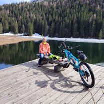
Trochu oddychu
Point of interest after 49.6 km
Billa

Photo after 51.5 km
Tak to je všechno, co jsme viděly během dvou dnů z Dachsteinu
Continue with Bikemap
Use, edit, or download this cycling route
You would like to ride Rakousko 2012-7.den-20.7.Pá or customize it for your own trip? Here is what you can do with this Bikemap route:
Free features
- Save this route as favorite or in collections
- Copy & plan your own version of this route
- Sync your route with Garmin or Wahoo
Premium features
Free trial for 3 days, or one-time payment. More about Bikemap Premium.
- Navigate this route on iOS & Android
- Export a GPX / KML file of this route
- Create your custom printout (try it for free)
- Download this route for offline navigation
Discover more Premium features.
Get Bikemap PremiumFrom our community
Other popular routes starting in Wörschach
 worschag naar salza
- Distance
- 26.7 km
- Ascent
- 490 m
- Descent
- 370 m
- Location
- Wörschach, Styria, Austria
 Schönmoos Runde
- Distance
- 22.8 km
- Ascent
- 590 m
- Descent
- 592 m
- Location
- Wörschach, Styria, Austria
 Wörschach-Spechtensee-Tauplitz-Trautenfels-Runde
- Distance
- 30 km
- Ascent
- 496 m
- Descent
- 500 m
- Location
- Wörschach, Styria, Austria
 Rakousko 2012-7.den-20.7.Pá
- Distance
- 53.9 km
- Ascent
- 772 m
- Descent
- 223 m
- Location
- Wörschach, Styria, Austria
 Ennsradweg
- Distance
- 214.6 km
- Ascent
- 914 m
- Descent
- 1,096 m
- Location
- Wörschach, Styria, Austria
 Hinterstoder - Bad Hall 3
- Distance
- 70.4 km
- Ascent
- 866 m
- Descent
- 1,153 m
- Location
- Wörschach, Styria, Austria
 Ruine Wolkenstein
- Distance
- 9 km
- Ascent
- 415 m
- Descent
- 516 m
- Location
- Wörschach, Styria, Austria
 Wörschach bis Spechtensee
- Distance
- 7.8 km
- Ascent
- 677 m
- Descent
- 251 m
- Location
- Wörschach, Styria, Austria
Open it in the app