

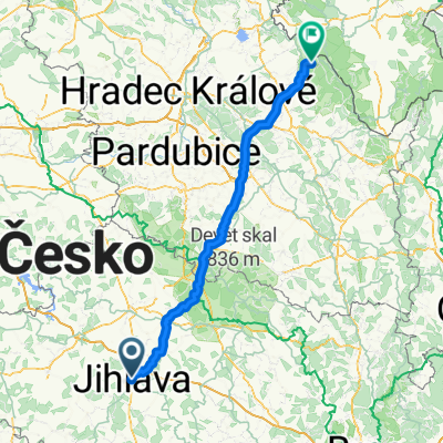
Jihlava - Třebíč - Raabs
A cycling route starting in Jihlava, Kraj Vysočina, Czechia.
Overview
About this route
- -:--
- Duration
- 137.7 km
- Distance
- 571 m
- Ascent
- 662 m
- Descent
- ---
- Avg. speed
- ---
- Avg. speed
Route quality
Waytypes & surfaces along the route
Waytypes
Track
33.4 km
(24 %)
Road
31.7 km
(23 %)
Surfaces
Paved
50.5 km
(37 %)
Unpaved
16.4 km
(12 %)
Asphalt
40.8 km
(30 %)
Paved (undefined)
9.4 km
(7 %)
Continue with Bikemap
Use, edit, or download this cycling route
You would like to ride Jihlava - Třebíč - Raabs or customize it for your own trip? Here is what you can do with this Bikemap route:
Free features
- Save this route as favorite or in collections
- Copy & plan your own version of this route
- Sync your route with Garmin or Wahoo
Premium features
Free trial for 3 days, or one-time payment. More about Bikemap Premium.
- Navigate this route on iOS & Android
- Export a GPX / KML file of this route
- Create your custom printout (try it for free)
- Download this route for offline navigation
Discover more Premium features.
Get Bikemap PremiumFrom our community
Other popular routes starting in Jihlava
 Jihlava - zborná - smrčná - cernak-trojan-jezena-hubenov-cerinek-kostelec-jihlava
- Distance
- 52.6 km
- Ascent
- 698 m
- Descent
- 698 m
- Location
- Jihlava, Kraj Vysočina, Czechia
 Brtnická, Йиглава до Sídliště Vajgar, Йиндржихув-Градец
- Distance
- 70.8 km
- Ascent
- 1,056 m
- Descent
- 1,090 m
- Location
- Jihlava, Kraj Vysočina, Czechia
 Jihlava to Uhlířské Janovice
- Distance
- 93.5 km
- Ascent
- 1,553 m
- Descent
- 1,651 m
- Location
- Jihlava, Kraj Vysočina, Czechia
 Jihlava-dolni_smrcne-VBeranov
- Distance
- 38 km
- Ascent
- 518 m
- Descent
- 497 m
- Location
- Jihlava, Kraj Vysočina, Czechia
 Jeníkov, Štoky, Polná, Heroltice, Rantířov
- Distance
- 57.1 km
- Ascent
- 463 m
- Descent
- 463 m
- Location
- Jihlava, Kraj Vysočina, Czechia
 Jihlava - Pavlov u Herálce (lom)
- Distance
- 21.5 km
- Ascent
- 364 m
- Descent
- 286 m
- Location
- Jihlava, Kraj Vysočina, Czechia
 JIhlava - Popice - Cerekvička - Luka nad Jihlava - JIhlava
- Distance
- 45.5 km
- Ascent
- 0 m
- Descent
- 0 m
- Location
- Jihlava, Kraj Vysočina, Czechia
 Jihlava - Deštné v O.h. Zákoutí
- Distance
- 139.2 km
- Ascent
- 1,365 m
- Descent
- 1,395 m
- Location
- Jihlava, Kraj Vysočina, Czechia
Open it in the app