

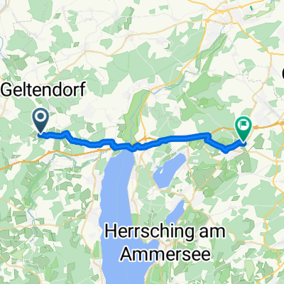
Geltendorf München Königsplatz
A cycling route starting in Eresing, Bavaria, Germany.
Overview
About this route
Von der S4 Station Geltendorf über Maisach und Karlsfeld nach München Königsplatz
6km ungeteert entlang vom Rangierbahnhof
- -:--
- Duration
- 66.4 km
- Distance
- 81 m
- Ascent
- 160 m
- Descent
- ---
- Avg. speed
- ---
- Avg. speed
Route quality
Waytypes & surfaces along the route
Waytypes
Quiet road
31.3 km
(47 %)
Path
13.7 km
(21 %)
Surfaces
Paved
56.7 km
(85 %)
Unpaved
5.6 km
(8 %)
Asphalt
55.8 km
(84 %)
Gravel
3.2 km
(5 %)
Continue with Bikemap
Use, edit, or download this cycling route
You would like to ride Geltendorf München Königsplatz or customize it for your own trip? Here is what you can do with this Bikemap route:
Free features
- Save this route as favorite or in collections
- Copy & plan your own version of this route
- Sync your route with Garmin or Wahoo
Premium features
Free trial for 3 days, or one-time payment. More about Bikemap Premium.
- Navigate this route on iOS & Android
- Export a GPX / KML file of this route
- Create your custom printout (try it for free)
- Download this route for offline navigation
Discover more Premium features.
Get Bikemap PremiumFrom our community
Other popular routes starting in Eresing
 Ammerseerunde Hauptstraße 31, Eresing nach Landsberger Straße 64, Inning am Ammersee
- Distance
- 50.9 km
- Ascent
- 240 m
- Descent
- 289 m
- Location
- Eresing, Bavaria, Germany
 Eresing - Hohenpeissenberg
- Distance
- 48.9 km
- Ascent
- 650 m
- Descent
- 276 m
- Location
- Eresing, Bavaria, Germany
 Eresing-Wessling
- Distance
- 21.2 km
- Ascent
- 173 m
- Descent
- 174 m
- Location
- Eresing, Bavaria, Germany
 48.104, 10.988 - 48.103, 10.980
- Distance
- 56.2 km
- Ascent
- 384 m
- Descent
- 335 m
- Location
- Eresing, Bavaria, Germany
 Rennrad 67 km
- Distance
- 67.6 km
- Ascent
- 228 m
- Descent
- 228 m
- Location
- Eresing, Bavaria, Germany
 Von Eresing bis Füssen
- Distance
- 93.2 km
- Ascent
- 819 m
- Descent
- 613 m
- Location
- Eresing, Bavaria, Germany
 Geltendorf-Hurlach
- Distance
- 66.1 km
- Ascent
- 419 m
- Descent
- 421 m
- Location
- Eresing, Bavaria, Germany
 13.09.10 Geltendorf-Oberstaufen
- Distance
- 4.4 km
- Ascent
- 54 m
- Descent
- 18 m
- Location
- Eresing, Bavaria, Germany
Open it in the app