

Silbertal - Kristberg - Hasa Hüsli Downhill
A cycling route starting in Sankt Gallenkirch, Vorarlberg, Austria.
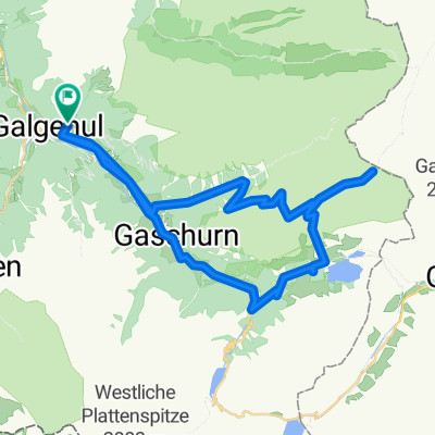
Overview
About this route
Von St. Gallenkirch durchs Silbertal auf den Kristberg über den Kamm zum Hasa Hüsli zurück nach Schruns und dann am Wasser entlang nach St. Gallenkirch.
555 hm und 1,575km für die Kristbergbahn von Gesamt abziehen!
3-4 Std.
- -:--
- Duration
- 50.3 km
- Distance
- 1,128 m
- Ascent
- 1,128 m
- Descent
- ---
- Avg. speed
- ---
- Avg. speed
Route highlights
Points of interest along the route
Point of interest after 14.6 km
Kristbergbahn 555hm
Point of interest after 25.3 km
Hasa Hüsli
Point of interest after 36.1 km
60+ km/h bergab
Point of interest after 39.2 km
Alpenbad Montafon
Continue with Bikemap
Use, edit, or download this cycling route
You would like to ride Silbertal - Kristberg - Hasa Hüsli Downhill or customize it for your own trip? Here is what you can do with this Bikemap route:
Free features
- Save this route as favorite or in collections
- Copy & plan your own version of this route
- Sync your route with Garmin or Wahoo
Premium features
Free trial for 3 days, or one-time payment. More about Bikemap Premium.
- Navigate this route on iOS & Android
- Export a GPX / KML file of this route
- Create your custom printout (try it for free)
- Download this route for offline navigation
Discover more Premium features.
Get Bikemap PremiumFrom our community
Other popular routes starting in Sankt Gallenkirch
 Gargellen-Silvretta-Stausse-retour
- Distance
- 74 km
- Ascent
- 1,921 m
- Descent
- 1,921 m
- Location
- Sankt Gallenkirch, Vorarlberg, Austria
 Koopsstausee von St. Gallenkirch
- Distance
- 45.4 km
- Ascent
- 1,623 m
- Descent
- 1,620 m
- Location
- Sankt Gallenkirch, Vorarlberg, Austria
 Rund um die Valisera Talstation
- Distance
- 0.7 km
- Ascent
- 4 m
- Descent
- 0 m
- Location
- Sankt Gallenkirch, Vorarlberg, Austria
 2023_RR_Silvretta_Zeinisjoch
- Distance
- 70.4 km
- Ascent
- 2,098 m
- Descent
- 2,096 m
- Location
- Sankt Gallenkirch, Vorarlberg, Austria
 von Galgenul ueber das Schlappinerjoch nach Klosters
- Distance
- 18.4 km
- Ascent
- 1,414 m
- Descent
- 1,124 m
- Location
- Sankt Gallenkirch, Vorarlberg, Austria
 Nach Schruns und zurück
- Distance
- 21.4 km
- Ascent
- 255 m
- Descent
- 255 m
- Location
- Sankt Gallenkirch, Vorarlberg, Austria
 Rund ins Montafontal
- Distance
- 55 km
- Ascent
- 1,173 m
- Descent
- 1,172 m
- Location
- Sankt Gallenkirch, Vorarlberg, Austria
 St. Gallenkirch - Bike 1
- Distance
- 7.2 km
- Ascent
- 409 m
- Descent
- 411 m
- Location
- Sankt Gallenkirch, Vorarlberg, Austria
Open it in the app