

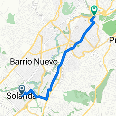
Ruta Jesus de Nazareth ( Giron - Transito - Santa Rosa I - Parque de Cillogallo)
A cycling route starting in Quito, Provincia de Pichincha, Ecuador.
Overview
About this route
Chicis estar 5 min antes de las horas establecidas.
- -:--
- Duration
- 3.3 km
- Distance
- 4 m
- Ascent
- 66 m
- Descent
- ---
- Avg. speed
- ---
- Avg. speed
Route quality
Waytypes & surfaces along the route
Waytypes
Quiet road
1.8 km
(55 %)
Road
1.5 km
(45 %)
Undefined
-0 km
(<1 %)
Surfaces
Paved
1.1 km
(33 %)
Asphalt
1.1 km
(32 %)
Paving stones
0 km
(1 %)
Undefined
2.2 km
(67 %)
Route highlights
Points of interest along the route
Point of interest after 0.4 km
Iglesia del Giron 06:25 am
Point of interest after 1.7 km
Manuela Cañizares y Ordoñes 06:35 am
Point of interest after 2.4 km
Capilla (entrada a Santa Rosa) 06:40 am
Continue with Bikemap
Use, edit, or download this cycling route
You would like to ride Ruta Jesus de Nazareth ( Giron - Transito - Santa Rosa I - Parque de Cillogallo) or customize it for your own trip? Here is what you can do with this Bikemap route:
Free features
- Save this route as favorite or in collections
- Copy & plan your own version of this route
- Sync your route with Garmin or Wahoo
Premium features
Free trial for 3 days, or one-time payment. More about Bikemap Premium.
- Navigate this route on iOS & Android
- Export a GPX / KML file of this route
- Create your custom printout (try it for free)
- Download this route for offline navigation
Discover more Premium features.
Get Bikemap PremiumFrom our community
Other popular routes starting in Quito
 CHIRIVUELTA
- Distance
- 66.2 km
- Ascent
- 1,272 m
- Descent
- 3,396 m
- Location
- Quito, Provincia de Pichincha, Ecuador
 El Cinto-Torouco-Cruz Loma
- Distance
- 19.4 km
- Ascent
- 1,032 m
- Descent
- 349 m
- Location
- Quito, Provincia de Pichincha, Ecuador
 Cancha Escuela de Bike Polo Patada heee Burra
- Distance
- 3.8 km
- Ascent
- 132 m
- Descent
- 154 m
- Location
- Quito, Provincia de Pichincha, Ecuador
 Quito - Chiriboga - Santo Domingo
- Distance
- 106.8 km
- Ascent
- 1,547 m
- Descent
- 3,949 m
- Location
- Quito, Provincia de Pichincha, Ecuador
 CHIRIVUELTA
- Distance
- 66.3 km
- Ascent
- 1,088 m
- Descent
- 3,253 m
- Location
- Quito, Provincia de Pichincha, Ecuador
 Parque Ecológico de solanda - Luluncoto (Bicinema)
- Distance
- 6.6 km
- Ascent
- 69 m
- Descent
- 125 m
- Location
- Quito, Provincia de Pichincha, Ecuador
 UNGUI - RIO BLANCO
- Distance
- 29 km
- Ascent
- 344 m
- Descent
- 1,525 m
- Location
- Quito, Provincia de Pichincha, Ecuador
 Ruta senderismo
- Distance
- 30 km
- Ascent
- 714 m
- Descent
- 711 m
- Location
- Quito, Provincia de Pichincha, Ecuador
Open it in the app