

Schlangenweg/WR/5-Wege
A cycling route starting in Möhnesee, North Rhine-Westphalia, Germany.
Overview
About this route
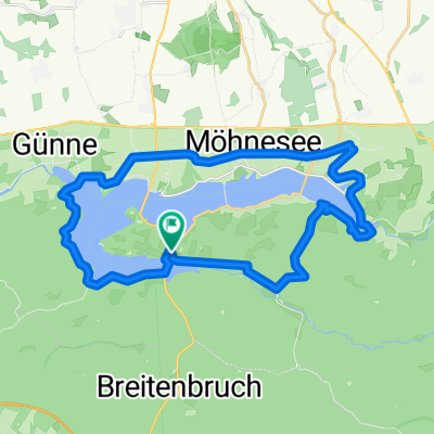
Start in Körbecke, über Fußgängerbrücke zum Südrand, an Böhms Imbiss vorbei Richtung Jugendherberge, rechts ab Richtung Rennweg, links auf Rennweg, links über den Klangpfad runter zum Asphaltweg Wilhelmsruher Straße, links über Asphalt bis zur Forststraße, kurz rechts und dann links rein. Forstweg folgen und rechts ab in den Ulrich-Prigge-Weg (Schlangenweg) bis der Rennweg kreuzt. Links ab auf Rennweg bis Kreuzung, dann links ab in schmalen Single-Trail.... sehr schön durch Wald bergab. Trail kreuzt Schlangenweg und weiter durch Wald bergab Singletrail folgen, Achtung, Ende sehr steil, Waldroute kreuzt! Rechts ab der Waldroute folgen zurück nach Wilhelmsruh. Nach Ferienpark links über Brücke, nach Brücke links rauf zu 5-Wege-Kreuzung, geradeaus ´runter zur grünen Hoffnung, rechts Richtung Hevebecken der Waldroute folgen, an kleiner Brücke links Trampelpfad Waldroute Richtung B229 folgen (fuckeliger Trail!). Rechts auf B229 rechtsseitig (!) auf Brücke Waldroute folgen. Am Ende der Brücke scharf rechts runter in den Wald und sofort links steilen Trail bergauf (!) folgen. Oben auf Asphalt (Wilhelmsruher Straße) links bis Torhaus. Rechts auf Parkplatz bis zum Ende dann links durch Gebüsch zum Rennweg rechts ab bis kurz nach Kreuzung zur Waldroute. Dann links runter in Trail zum Südrand/Buchenweg. Forstweg kreuzen, kurz links und dann rechts weiter auf Trail. Hinter der Hecke links durch Buchenweg ´runter zum Südufer (L857) und queren zur Fußgängerbrücke nach Körbecke.....
- -:--
- Duration
- 25.3 km
- Distance
- 409 m
- Ascent
- 418 m
- Descent
- ---
- Avg. speed
- ---
- Avg. speed
Route quality
Waytypes & surfaces along the route
Waytypes
Track
11.2 km
(44 %)
Quiet road
5.6 km
(22 %)
Surfaces
Paved
9.3 km
(37 %)
Unpaved
14.1 km
(56 %)
Asphalt
8.9 km
(35 %)
Gravel
6.9 km
(27 %)
Continue with Bikemap
Use, edit, or download this cycling route
You would like to ride Schlangenweg/WR/5-Wege or customize it for your own trip? Here is what you can do with this Bikemap route:
Free features
- Save this route as favorite or in collections
- Copy & plan your own version of this route
- Sync your route with Garmin or Wahoo
Premium features
Free trial for 3 days, or one-time payment. More about Bikemap Premium.
- Navigate this route on iOS & Android
- Export a GPX / KML file of this route
- Create your custom printout (try it for free)
- Download this route for offline navigation
Discover more Premium features.
Get Bikemap PremiumFrom our community
Other popular routes starting in Möhnesee
 Möhnesee
- Distance
- 18.1 km
- Ascent
- 174 m
- Descent
- 175 m
- Location
- Möhnesee, North Rhine-Westphalia, Germany
 MöhneWarstein
- Distance
- 65.1 km
- Ascent
- 806 m
- Descent
- 805 m
- Location
- Möhnesee, North Rhine-Westphalia, Germany
 Möhnesee-Neuhaus
- Distance
- 39.7 km
- Ascent
- 735 m
- Descent
- 735 m
- Location
- Möhnesee, North Rhine-Westphalia, Germany
 Möhneseerundkurs
- Distance
- 19.5 km
- Ascent
- 185 m
- Descent
- 185 m
- Location
- Möhnesee, North Rhine-Westphalia, Germany
 Rundtour Möhnesee
- Distance
- 29.5 km
- Ascent
- 174 m
- Descent
- 176 m
- Location
- Möhnesee, North Rhine-Westphalia, Germany
 Möhneseetour
- Distance
- 29.6 km
- Ascent
- 289 m
- Descent
- 298 m
- Location
- Möhnesee, North Rhine-Westphalia, Germany
 Enjoy The Forest
- Distance
- 35.4 km
- Ascent
- 499 m
- Descent
- 495 m
- Location
- Möhnesee, North Rhine-Westphalia, Germany
 Wildwechsel-Weg
- Distance
- 20.6 km
- Ascent
- 370 m
- Descent
- 371 m
- Location
- Möhnesee, North Rhine-Westphalia, Germany
Open it in the app