

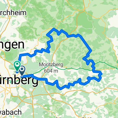
Mögeldorf-Leutenbach-Eckental
A cycling route starting in Schwaig, Bavaria, Germany.
Overview
About this route
Mögeldorf Thäterstraße 45
Kalchreuth
Kreuzweiher
Kleinsendelbach
Großenbuch
Hetzkeser Berg
Leutenbach-Gaststätte Rumpler
Hundsboden
Egloffstein
Thuisbrunn
Gräfenberg
Weißenohe
Igensdorf
Stöckach
Eckental/Frohnhof
- -:--
- Duration
- 348.1 km
- Distance
- 1,377 m
- Ascent
- 1,361 m
- Descent
- ---
- Avg. speed
- ---
- Avg. speed
Route quality
Waytypes & surfaces along the route
Waytypes
Busy road
201.4 km
(58 %)
Path
42.3 km
(12 %)
Surfaces
Paved
279.3 km
(80 %)
Unpaved
13.8 km
(4 %)
Asphalt
258.8 km
(74 %)
Paving stones
13.2 km
(4 %)
Continue with Bikemap
Use, edit, or download this cycling route
You would like to ride Mögeldorf-Leutenbach-Eckental or customize it for your own trip? Here is what you can do with this Bikemap route:
Free features
- Save this route as favorite or in collections
- Copy & plan your own version of this route
- Sync your route with Garmin or Wahoo
Premium features
Free trial for 3 days, or one-time payment. More about Bikemap Premium.
- Navigate this route on iOS & Android
- Export a GPX / KML file of this route
- Create your custom printout (try it for free)
- Download this route for offline navigation
Discover more Premium features.
Get Bikemap PremiumFrom our community
Other popular routes starting in Schwaig
 Hersbrucker und Fränkische ADFC 6.7.14
- Distance
- 146.8 km
- Ascent
- 1,184 m
- Descent
- 1,174 m
- Location
- Schwaig, Bavaria, Germany
 Schöne Runde
- Distance
- 32.2 km
- Ascent
- 281 m
- Descent
- 281 m
- Location
- Schwaig, Bavaria, Germany
 Schwaig - Osternohe - Hormersdorf - Hersbruck - Schwaig
- Distance
- 63.9 km
- Ascent
- 432 m
- Descent
- 432 m
- Location
- Schwaig, Bavaria, Germany
 Glatzenstein
- Distance
- 52.7 km
- Ascent
- 637 m
- Descent
- 642 m
- Location
- Schwaig, Bavaria, Germany
 Nürnberg 01
- Distance
- 51.7 km
- Ascent
- 212 m
- Descent
- 212 m
- Location
- Schwaig, Bavaria, Germany
 Hersbrucker und Fränkische ADFC 6.7.14
- Distance
- 146 km
- Ascent
- 1,198 m
- Descent
- 1,189 m
- Location
- Schwaig, Bavaria, Germany
 5 Brügglersweg - Trailrunde- Tiergarten
- Distance
- 32.7 km
- Ascent
- 189 m
- Descent
- 189 m
- Location
- Schwaig, Bavaria, Germany
 Tiergarten - Gnadenberg Rundtour leicht
- Distance
- 51.3 km
- Ascent
- 260 m
- Descent
- 263 m
- Location
- Schwaig, Bavaria, Germany
Open it in the app