

Bad Säckingen nach Schaffhausen
A cycling route starting in Stein, Canton of Aargau, Switzerland.
Overview
About this route
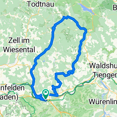
Schöne Strecke am Rhein entlang bis Waldshut, dann Richtung Klettgau an der Wutach entlang.Nur zwischen Waldshut und Tiengen wenige Kilometer an der B 34 . Sehr gut markierte Strecke. Streckenführung so, dass keine Hauptverkehrsstraßen gekreuzt werden müssen, da an solchen Stellen immer Unterführungen.
von Säckingen bis Waldshut auf dem Rheinradweg
von Waldshut an der Wutach entlang auf der Strecke des Südschwarzwaldradweges
ab Erzingen Veloroute 77 (Rigi,Reuss,Klettgau
Bahnverbindung zurück nach Bad Säckingen an verschiedenen Orten möglich: Waldshut, Tiengen, Erzingen und schließlich Schaffhausen
- -:--
- Duration
- 75.5 km
- Distance
- 332 m
- Ascent
- 231 m
- Descent
- ---
- Avg. speed
- ---
- Avg. speed
Continue with Bikemap
Use, edit, or download this cycling route
You would like to ride Bad Säckingen nach Schaffhausen or customize it for your own trip? Here is what you can do with this Bikemap route:
Free features
- Save this route as favorite or in collections
- Copy & plan your own version of this route
- Sync your route with Garmin or Wahoo
Premium features
Free trial for 3 days, or one-time payment. More about Bikemap Premium.
- Navigate this route on iOS & Android
- Export a GPX / KML file of this route
- Create your custom printout (try it for free)
- Download this route for offline navigation
Discover more Premium features.
Get Bikemap PremiumFrom our community
Other popular routes starting in Stein
 Bad Säckingen Rheinroute Waldshut
- Distance
- 59.7 km
- Ascent
- 469 m
- Descent
- 472 m
- Location
- Stein, Canton of Aargau, Switzerland
 19,04.19 venerdi pascqua 👍
- Distance
- 31.4 km
- Ascent
- 119 m
- Descent
- 119 m
- Location
- Stein, Canton of Aargau, Switzerland
 Erste Tour von Wehr nach Laufenburg
- Distance
- 32.9 km
- Ascent
- 503 m
- Descent
- 479 m
- Location
- Stein, Canton of Aargau, Switzerland
 2TT/2016 Bad Säckingen - Bern
- Distance
- 114 km
- Ascent
- 860 m
- Descent
- 605 m
- Location
- Stein, Canton of Aargau, Switzerland
 Wehr - Todtmoos - Bernau - Tiefenstein - Oberwihl - Murg
- Distance
- 109.1 km
- Ascent
- 1,179 m
- Descent
- 1,179 m
- Location
- Stein, Canton of Aargau, Switzerland
 Vorschlag Route sehr schön, wenig Verkehr
- Distance
- 80.7 km
- Ascent
- 2,565 m
- Descent
- 2,606 m
- Location
- Stein, Canton of Aargau, Switzerland
 Murgtaltour
- Distance
- 26.2 km
- Ascent
- 654 m
- Descent
- 599 m
- Location
- Stein, Canton of Aargau, Switzerland
 Fisibach-Schneisingen-Gansingen
- Distance
- 106.8 km
- Ascent
- 687 m
- Descent
- 687 m
- Location
- Stein, Canton of Aargau, Switzerland
Open it in the app