

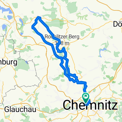
Rentnersruh-Forzbachl-Flugplatz-Wasserschloß
A cycling route starting in Chemnitz, Saxony, Germany.
Overview
About this route
Die Strecke wurde so ausgesucht, dass so wenig wie möglich auf starkbefahrenen Straßen gefahren werden muss.
- -:--
- Duration
- 58.6 km
- Distance
- 434 m
- Ascent
- 433 m
- Descent
- ---
- Avg. speed
- ---
- Avg. speed

Route quality
Waytypes & surfaces along the route
Waytypes
Quiet road
20.3 km
(35 %)
Busy road
18.2 km
(31 %)
Surfaces
Paved
48.4 km
(83 %)
Unpaved
7.1 km
(12 %)
Asphalt
46.8 km
(80 %)
Loose gravel
3.3 km
(6 %)
Route highlights
Points of interest along the route
Point of interest after 4.7 km
Die Runde im Uhrzeigersinn fahren
Point of interest after 9.6 km
Einsiedler-Brauerei
Point of interest after 10.2 km
Juliane Kluge ist hier verunglückt
Point of interest after 14.3 km
Ortsteil Kamerun
Point of interest after 15.8 km
Gaststätte Vetters Hof
Point of interest after 16.6 km
neue Kläranlage für Eibenberg
Point of interest after 19.7 km
Die Zwönitz-Arena
Point of interest after 23.5 km
Der neue Radweg nach Thalheim
Point of interest after 27.3 km
Ein roter Turm mit grünem Dach
Point of interest after 27.6 km
Rentnersruh, mit Kleinerzgebirge und "Futterkrippen"
Point of interest after 29.7 km
Stark befahrene Hauptstraße aber es rollt besser bergauf als über die Feld und Waldwege!
Point of interest after 30 km
ganz schlechte Wald und Feldwege
Point of interest after 33.4 km
Trial - Platz Thalheim
Point of interest after 34.7 km
Die Forzbachelquelle mit Sitzmöglichkeit
Point of interest after 38.1 km
Ein Bauernhof
Point of interest after 38.2 km
Ausblick zur Pfaffenhainerlänge
Point of interest after 42.9 km
Schwarzer Stein
Point of interest after 44.2 km
Jahndorfer Freibad
Point of interest after 47.7 km
Das Wasserschloss Klaffenbach
Continue with Bikemap
Use, edit, or download this cycling route
You would like to ride Rentnersruh-Forzbachl-Flugplatz-Wasserschloß or customize it for your own trip? Here is what you can do with this Bikemap route:
Free features
- Save this route as favorite or in collections
- Copy & plan your own version of this route
- Sync your route with Garmin or Wahoo
Premium features
Free trial for 3 days, or one-time payment. More about Bikemap Premium.
- Navigate this route on iOS & Android
- Export a GPX / KML file of this route
- Create your custom printout (try it for free)
- Download this route for offline navigation
Discover more Premium features.
Get Bikemap PremiumFrom our community
Other popular routes starting in Chemnitz
 Chemnitz - Kohren Salis
- Distance
- 96.3 km
- Ascent
- 522 m
- Descent
- 526 m
- Location
- Chemnitz, Saxony, Germany
 West- Nord- Runde (Grüna, Glöse, ...)
- Distance
- 49.8 km
- Ascent
- 339 m
- Descent
- 339 m
- Location
- Chemnitz, Saxony, Germany
 kleine Runde um Chemnitz mit Abstecher nach Glösa
- Distance
- 30.5 km
- Ascent
- 167 m
- Descent
- 167 m
- Location
- Chemnitz, Saxony, Germany
 Chemnitz - Rochlitzer Berg - Bad Lausick - Chemnitz 2
- Distance
- 108.4 km
- Ascent
- 546 m
- Descent
- 543 m
- Location
- Chemnitz, Saxony, Germany
 4h Runde Chemnitz
- Distance
- 107.7 km
- Ascent
- 582 m
- Descent
- 572 m
- Location
- Chemnitz, Saxony, Germany
 Abendrunde I
- Distance
- 30.6 km
- Ascent
- 218 m
- Descent
- 218 m
- Location
- Chemnitz, Saxony, Germany
 Chemnitz Küchwald - Kriebstein und zurück
- Distance
- 71.5 km
- Ascent
- 567 m
- Descent
- 567 m
- Location
- Chemnitz, Saxony, Germany
 Goldner Hahn _ Wasserschloß
- Distance
- 34.3 km
- Ascent
- 670 m
- Descent
- 675 m
- Location
- Chemnitz, Saxony, Germany
Open it in the app