

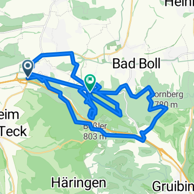
Aichelberg-Ellwangen
A cycling route starting in Aichelberg, Baden-Wurttemberg, Germany.
Overview
About this route
- -:--
- Duration
- 92.4 km
- Distance
- 853 m
- Ascent
- 825 m
- Descent
- ---
- Avg. speed
- ---
- Max. altitude
Route quality
Waytypes & surfaces along the route
Waytypes
Road
24 km
(26 %)
Quiet road
13.9 km
(15 %)
Surfaces
Paved
73 km
(79 %)
Unpaved
0.9 km
(1 %)
Asphalt
72.1 km
(78 %)
Paved (undefined)
0.9 km
(1 %)
Route highlights
Points of interest along the route
Point of interest after 0 km
Continue with Bikemap
Use, edit, or download this cycling route
You would like to ride Aichelberg-Ellwangen or customize it for your own trip? Here is what you can do with this Bikemap route:
Free features
- Save this route as favorite or in collections
- Copy & plan your own version of this route
- Split it into stages to create a multi-day tour
- Sync your route with Garmin or Wahoo
Premium features
Free trial for 3 days, or one-time payment. More about Bikemap Premium.
- Navigate this route on iOS & Android
- Export a GPX / KML file of this route
- Create your custom printout (try it for free)
- Download this route for offline navigation
Discover more Premium features.
Get Bikemap PremiumFrom our community
Other popular routes starting in Aichelberg
 Aichelberg
- Distance
- 28.2 km
- Ascent
- 824 m
- Descent
- 786 m
- Location
- Aichelberg, Baden-Wurttemberg, Germany
 Deutsches-Haus
- Distance
- 10.9 km
- Ascent
- 275 m
- Descent
- 245 m
- Location
- Aichelberg, Baden-Wurttemberg, Germany
 Carl-Benz-Straße 32, Weilheim an der Teck nach Schanbach Kreisverkehr - Aichwald
- Distance
- 27.4 km
- Ascent
- 280 m
- Descent
- 214 m
- Location
- Aichelberg, Baden-Wurttemberg, Germany
 KA Tag 3
- Distance
- 127.2 km
- Ascent
- 1,106 m
- Descent
- 1,377 m
- Location
- Aichelberg, Baden-Wurttemberg, Germany
 Aichelberg-Ellwangen
- Distance
- 92.4 km
- Ascent
- 853 m
- Descent
- 825 m
- Location
- Aichelberg, Baden-Wurttemberg, Germany
 Route01
- Distance
- 41.5 km
- Ascent
- 1,099 m
- Descent
- 746 m
- Location
- Aichelberg, Baden-Wurttemberg, Germany
 20180314_Albtraufradteam
- Distance
- 30.2 km
- Ascent
- 731 m
- Descent
- 813 m
- Location
- Aichelberg, Baden-Wurttemberg, Germany
 ST Aichwald
- Distance
- 28.2 km
- Ascent
- 825 m
- Descent
- 787 m
- Location
- Aichelberg, Baden-Wurttemberg, Germany
Open it in the app