

Burg Satzvey
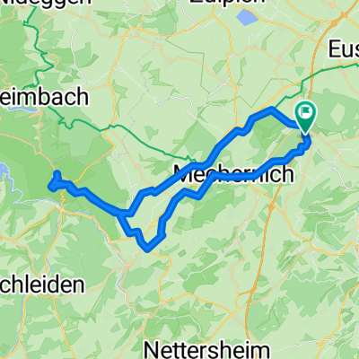
A cycling route starting in Mechernich, North Rhine-Westphalia, Germany.
Overview
About this route
Burg Satzvey
- -:--
- Duration
- 60.5 km
- Distance
- 74 m
- Ascent
- 327 m
- Descent
- ---
- Avg. speed
- ---
- Avg. speed

Route quality
Waytypes & surfaces along the route
Waytypes
Track
20.8 km
(34 %)
Quiet road
18.8 km
(31 %)
Surfaces
Paved
41.7 km
(69 %)
Unpaved
9.2 km
(15 %)
Asphalt
30.7 km
(51 %)
Paved (undefined)
10.4 km
(17 %)
Route highlights
Points of interest along the route

Photo after 2.8 km
1000 jährige Eiche

Photo after 6.9 km
Burg Satzvey

Photo after 9.3 km
Burg Veynau

Photo after 26.6 km
Friesheim (Weiße Burg)

Point of interest after 31.7 km
Chinarestaurant Ling Bonner Ring 29 - 50374 Erftstadt-Lechenich Telefon 02235/6677 täglich 11:30 - 15.00 und 17:30 -23:30

Photo after 33.5 km
Schlosspark Lechenich
Continue with Bikemap
Use, edit, or download this cycling route
You would like to ride Burg Satzvey or customize it for your own trip? Here is what you can do with this Bikemap route:
Free features
- Save this route as favorite or in collections
- Copy & plan your own version of this route
- Sync your route with Garmin or Wahoo
Premium features
Free trial for 3 days, or one-time payment. More about Bikemap Premium.
- Navigate this route on iOS & Android
- Export a GPX / KML file of this route
- Create your custom printout (try it for free)
- Download this route for offline navigation
Discover more Premium features.
Get Bikemap PremiumFrom our community
Other popular routes starting in Mechernich
 Lessenich - Wolfgarten (Kermeter) und zurück
- Distance
- 46.4 km
- Ascent
- 457 m
- Descent
- 454 m
- Location
- Mechernich, North Rhine-Westphalia, Germany
 Kommern-Nideggen-Heimbach-Kommern
- Distance
- 53.1 km
- Ascent
- 631 m
- Descent
- 631 m
- Location
- Mechernich, North Rhine-Westphalia, Germany
 Runde über Schleiden
- Distance
- 43.6 km
- Ascent
- 585 m
- Descent
- 574 m
- Location
- Mechernich, North Rhine-Westphalia, Germany
 Rund um den Rurstausee
- Distance
- 104.5 km
- Ascent
- 1,588 m
- Descent
- 1,609 m
- Location
- Mechernich, North Rhine-Westphalia, Germany
 Lessenich - Eschweilerbachtal- Lessenich
- Distance
- 24.5 km
- Ascent
- 244 m
- Descent
- 244 m
- Location
- Mechernich, North Rhine-Westphalia, Germany
 Eifelhöhen 2020
- Distance
- 46.9 km
- Ascent
- 637 m
- Descent
- 632 m
- Location
- Mechernich, North Rhine-Westphalia, Germany
 EifelSchleife Burg Satzvey (Stadt Mechernich) - EifelSchleife Burg Satzvey (Stadt Mechernich)
- Distance
- 7.3 km
- Ascent
- 105 m
- Descent
- 109 m
- Location
- Mechernich, North Rhine-Westphalia, Germany
 www.Rad-Rebellen.de - Tour 2
- Distance
- 32.1 km
- Ascent
- 408 m
- Descent
- 410 m
- Location
- Mechernich, North Rhine-Westphalia, Germany
Open it in the app