

Nanos
A cycling route starting in Vipava, Vipava, Slovenia.
Overview
About this route
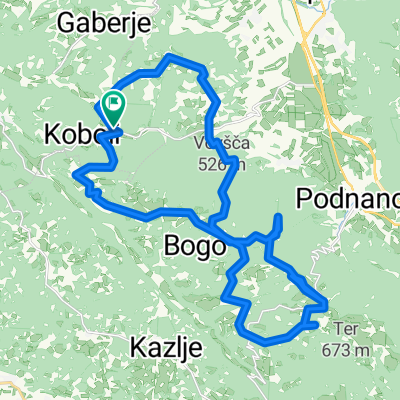
Start v Podnanosu, po cesti do robu in nato do Vojkove koče na Nanosu. Po markirani pešpoti do Turistične kmetije Abram, ter nato spust do Vipave.
Prvi del vzpona do robu je dokaj strm (cesta je v celoti asfaltirana), a s primernim tempom lahko premagljiv, nato se prične pešpot po samem robu do vrha planote. Spust se prične v smeri Abrama (markirana pešpot), do koder ni nobenih težavnih vzponov/spustov, saj pot pelje po planoti.
Spust z Abrama v Vipavo (ne v smeri Gradiške ture, ki te pripelje na plezališče) je kamnit, na nekaterih mestih precej tehnično zahteven, vsekakor pa zelo razgiban in naporen.
Pot se zaključi v Vipavi. Primerno parkirišče za začetek in konec poti je pred Škofijsko gimnazijo v Vipavi. Transfer Vipava-Podnanos poteki po stari cesti Vipava-Razdrto.
- -:--
- Duration
- 27.6 km
- Distance
- 1,129 m
- Ascent
- 1,237 m
- Descent
- ---
- Avg. speed
- ---
- Avg. speed

Continue with Bikemap
Use, edit, or download this cycling route
You would like to ride Nanos or customize it for your own trip? Here is what you can do with this Bikemap route:
Free features
- Save this route as favorite or in collections
- Copy & plan your own version of this route
- Sync your route with Garmin or Wahoo
Premium features
Free trial for 3 days, or one-time payment. More about Bikemap Premium.
- Navigate this route on iOS & Android
- Export a GPX / KML file of this route
- Create your custom printout (try it for free)
- Download this route for offline navigation
Discover more Premium features.
Get Bikemap PremiumFrom our community
Other popular routes starting in Vipava
 VRHE VOLJA 2013
- Distance
- 34.2 km
- Ascent
- 974 m
- Descent
- 974 m
- Location
- Vipava, Vipava, Slovenia
 MTB Ter
- Distance
- 18.8 km
- Ascent
- 448 m
- Descent
- 448 m
- Location
- Vipava, Vipava, Slovenia
 Col - Javornik
- Distance
- 22.9 km
- Ascent
- 783 m
- Descent
- 783 m
- Location
- Vipava, Vipava, Slovenia
 SELO - BRANICA - ŠTJAK
- Distance
- 8.2 km
- Ascent
- 424 m
- Descent
- 426 m
- Location
- Vipava, Vipava, Slovenia
 Vipavska tura
- Distance
- 31.3 km
- Ascent
- 809 m
- Descent
- 809 m
- Location
- Vipava, Vipava, Slovenia
 NA NANOS in dol
- Distance
- 43.1 km
- Ascent
- 877 m
- Descent
- 874 m
- Location
- Vipava, Vipava, Slovenia
 NANOS
NANOS- Distance
- 30.2 km
- Ascent
- 1,227 m
- Descent
- 1,228 m
- Location
- Vipava, Vipava, Slovenia
 Tura po Vipavski dolini
- Distance
- 43.2 km
- Ascent
- 835 m
- Descent
- 834 m
- Location
- Vipava, Vipava, Slovenia
Open it in the app