

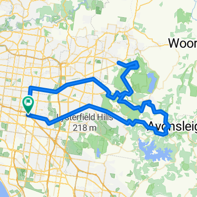
Glen Waverley to City (Crown)
A cycling route starting in Notting Hill, Victoria, Australia.
Overview
About this route
Apart from some side street riding from Springvale Road to Foster Road, utilises Scotchman's Creek, Gardiner and Main Yarra trails into the city - great comfortable ride and ideal beginners track for those who want to start putting some k's down.
- -:--
- Duration
- 24.8 km
- Distance
- 64 m
- Ascent
- 165 m
- Descent
- ---
- Avg. speed
- ---
- Avg. speed

Continue with Bikemap
Use, edit, or download this cycling route
You would like to ride Glen Waverley to City (Crown) or customize it for your own trip? Here is what you can do with this Bikemap route:
Free features
- Save this route as favorite or in collections
- Copy & plan your own version of this route
- Sync your route with Garmin or Wahoo
Premium features
Free trial for 3 days, or one-time payment. More about Bikemap Premium.
- Navigate this route on iOS & Android
- Export a GPX / KML file of this route
- Create your custom printout (try it for free)
- Download this route for offline navigation
Discover more Premium features.
Get Bikemap PremiumFrom our community
Other popular routes starting in Notting Hill
 Warrigal Road to Forster Road
- Distance
- 4.6 km
- Ascent
- 6 m
- Descent
- 43 m
- Location
- Notting Hill, Victoria, Australia
 black kettle camberwell waverley hills
- Distance
- 100.1 km
- Ascent
- 856 m
- Descent
- 836 m
- Location
- Notting Hill, Victoria, Australia
 To Glen Waverley Statiion
- Distance
- 7.2 km
- Ascent
- 80 m
- Descent
- 59 m
- Location
- Notting Hill, Victoria, Australia
 Mt Waverley Epic
- Distance
- 6 km
- Ascent
- 75 m
- Descent
- 76 m
- Location
- Notting Hill, Victoria, Australia
 Sassafras Montrose Sassafras Patch Emerald
- Distance
- 113.2 km
- Ascent
- 1,294 m
- Descent
- 1,296 m
- Location
- Notting Hill, Victoria, Australia
 Ferntree Gully, The Basin
- Distance
- 55.6 km
- Ascent
- 314 m
- Descent
- 314 m
- Location
- Notting Hill, Victoria, Australia
 Glen Wav Hermans Cnr Kallista back via Boronia Rd
- Distance
- 65.4 km
- Ascent
- 673 m
- Descent
- 675 m
- Location
- Notting Hill, Victoria, Australia
 Tues TBug from Churchill Park to Lot 88 and back
- Distance
- 48.9 km
- Ascent
- 235 m
- Descent
- 233 m
- Location
- Notting Hill, Victoria, Australia
Open it in the app