

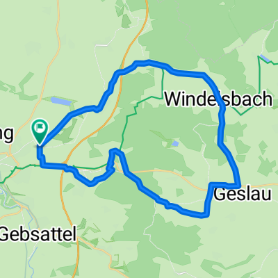
Rothenburg/Tauber nach Dinkelsbühl
A cycling route starting in Rothenburg upon Tauber, Bavaria, Germany.
Overview
About this route
14.Etappe von HH-München. Teilweise sehr hügelige Strecke.Lange Auffahrt nach Schillingsfürst, sollte nicht umgangen werden. Wege,vor Feuchtwangen,nur sehr loser Schotter.Bei der Abfahrt und in Kurven mehr als lästig.Dinkelsbühl entschädigt für die Anstrengungen, mit guten Unterkünften und toller Bewirtung.
- -:--
- Duration
- 52.3 km
- Distance
- 420 m
- Ascent
- 403 m
- Descent
- ---
- Avg. speed
- ---
- Avg. speed

Continue with Bikemap
Use, edit, or download this cycling route
You would like to ride Rothenburg/Tauber nach Dinkelsbühl or customize it for your own trip? Here is what you can do with this Bikemap route:
Free features
- Save this route as favorite or in collections
- Copy & plan your own version of this route
- Sync your route with Garmin or Wahoo
Premium features
Free trial for 3 days, or one-time payment. More about Bikemap Premium.
- Navigate this route on iOS & Android
- Export a GPX / KML file of this route
- Create your custom printout (try it for free)
- Download this route for offline navigation
Discover more Premium features.
Get Bikemap PremiumFrom our community
Other popular routes starting in Rothenburg upon Tauber
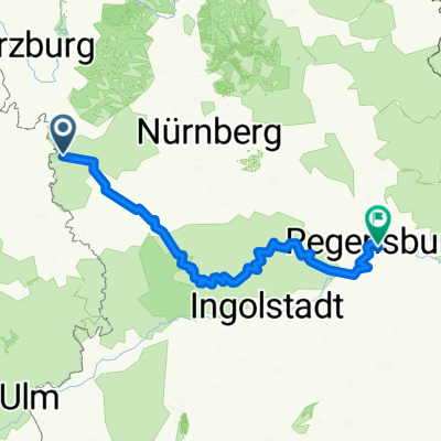 Rothenburg-Regensburg
- Distance
- 263.4 km
- Ascent
- 1,292 m
- Descent
- 1,373 m
- Location
- Rothenburg upon Tauber, Bavaria, Germany
 Taubertal-Panorama
- Distance
- 52.4 km
- Ascent
- 733 m
- Descent
- 895 m
- Location
- Rothenburg upon Tauber, Bavaria, Germany
 Rothenburg Burgbernheim Runde
- Distance
- 30.5 km
- Ascent
- 266 m
- Descent
- 275 m
- Location
- Rothenburg upon Tauber, Bavaria, Germany
 Altmühlradweg: Rothenburg-Kelheim
- Distance
- 244.8 km
- Ascent
- 316 m
- Descent
- 400 m
- Location
- Rothenburg upon Tauber, Bavaria, Germany
 Rund um Rothenburg
- Distance
- 23.1 km
- Ascent
- 463 m
- Descent
- 445 m
- Location
- Rothenburg upon Tauber, Bavaria, Germany
 Rothenburg-Tauberquelle
- Distance
- 44.7 km
- Ascent
- 278 m
- Descent
- 278 m
- Location
- Rothenburg upon Tauber, Bavaria, Germany
 Frankenhöhe
- Distance
- 25 km
- Ascent
- 219 m
- Descent
- 224 m
- Location
- Rothenburg upon Tauber, Bavaria, Germany
 35_Rothenburg ob der Tauber – Leutershausen
- Distance
- 41.9 km
- Ascent
- 171 m
- Descent
- 168 m
- Location
- Rothenburg upon Tauber, Bavaria, Germany
Open it in the app