

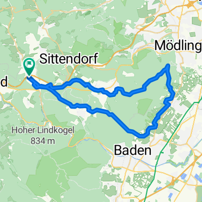
Heiligenkreuz-Rosental-Zoblhof-Mayerling
A cycling route starting in Heiligenkreuz, Lower Austria, Austria.
Overview
About this route
Winterrunde mit viel Asphaltanteil, kann je nach Zustande der unbefestigten Wege auch im Wald gefahren werden.
- -:--
- Duration
- 35.3 km
- Distance
- 768 m
- Ascent
- 768 m
- Descent
- ---
- Avg. speed
- ---
- Avg. speed

Continue with Bikemap
Use, edit, or download this cycling route
You would like to ride Heiligenkreuz-Rosental-Zoblhof-Mayerling or customize it for your own trip? Here is what you can do with this Bikemap route:
Free features
- Save this route as favorite or in collections
- Copy & plan your own version of this route
- Sync your route with Garmin or Wahoo
Premium features
Free trial for 3 days, or one-time payment. More about Bikemap Premium.
- Navigate this route on iOS & Android
- Export a GPX / KML file of this route
- Create your custom printout (try it for free)
- Download this route for offline navigation
Discover more Premium features.
Get Bikemap PremiumFrom our community
Other popular routes starting in Heiligenkreuz
 veto run test
- Distance
- 77.7 km
- Ascent
- 831 m
- Descent
- 876 m
- Location
- Heiligenkreuz, Lower Austria, Austria
 Helenental Strecke
- Distance
- 23.8 km
- Ascent
- 481 m
- Descent
- 481 m
- Location
- Heiligenkreuz, Lower Austria, Austria
 75km Tullnerbach
- Distance
- 80.3 km
- Ascent
- 974 m
- Descent
- 976 m
- Location
- Heiligenkreuz, Lower Austria, Austria
 Bad.24KM-450HM
- Distance
- 23.8 km
- Ascent
- 500 m
- Descent
- 500 m
- Location
- Heiligenkreuz, Lower Austria, Austria
 Bergfex Wienerwald Reiseneck Tour
- Distance
- 17.9 km
- Ascent
- 350 m
- Descent
- 349 m
- Location
- Heiligenkreuz, Lower Austria, Austria
 Runde Anninger
- Distance
- 34.6 km
- Ascent
- 716 m
- Descent
- 717 m
- Location
- Heiligenkreuz, Lower Austria, Austria
 Ö-tour mit bigi 10.-15.7.2011
- Distance
- 769.1 km
- Ascent
- 6,757 m
- Descent
- 6,567 m
- Location
- Heiligenkreuz, Lower Austria, Austria
 GA Neusiedl
- Distance
- 219.6 km
- Ascent
- 417 m
- Descent
- 416 m
- Location
- Heiligenkreuz, Lower Austria, Austria
Open it in the app