

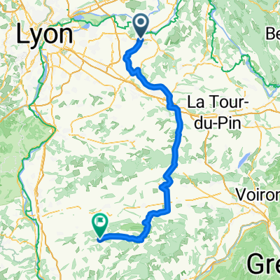
Etappe 7 Pont de Cheruy ---> Romans sur Isere 116 km
A cycling route starting in Pont-de-Chéruy, Auvergne-Rhône-Alpes, France.
Overview
About this route
Van .... Hotel Le Zepi 30, rue Giffard 38230 Pont de Cheruy + 33 478322002
Naar ....Comfort hotel Romans/Clos des Tanneurs Avenue Adolphe Figuet 26100 Romans sur Isere + 33 475051020
- -:--
- Duration
- 115.9 km
- Distance
- 822 m
- Ascent
- 865 m
- Descent
- ---
- Avg. speed
- ---
- Avg. speed

Route quality
Waytypes & surfaces along the route
Waytypes
Road
60.6 km
(52 %)
Quiet road
40.6 km
(35 %)
Surfaces
Paved
20.7 km
(18 %)
Asphalt
20.4 km
(18 %)
Paved (undefined)
0.3 km
(<1 %)
Undefined
95.2 km
(82 %)
Continue with Bikemap
Use, edit, or download this cycling route
You would like to ride Etappe 7 Pont de Cheruy ---> Romans sur Isere 116 km or customize it for your own trip? Here is what you can do with this Bikemap route:
Free features
- Save this route as favorite or in collections
- Copy & plan your own version of this route
- Sync your route with Garmin or Wahoo
Premium features
Free trial for 3 days, or one-time payment. More about Bikemap Premium.
- Navigate this route on iOS & Android
- Export a GPX / KML file of this route
- Create your custom printout (try it for free)
- Download this route for offline navigation
Discover more Premium features.
Get Bikemap PremiumFrom our community
Other popular routes starting in Pont-de-Chéruy
 pt de cheruy-hauterives
- Distance
- 106.5 km
- Ascent
- 547 m
- Descent
- 436 m
- Location
- Pont-de-Chéruy, Auvergne-Rhône-Alpes, France
 pt de cheruy-hauterives
- Distance
- 92.5 km
- Ascent
- 711 m
- Descent
- 582 m
- Location
- Pont-de-Chéruy, Auvergne-Rhône-Alpes, France
 12 Rue des Quatre Buissons, Tignieu-Jameyzieu à 4 Rue du Bochet, Tignieu-Jameyzieu
- Distance
- 0.7 km
- Ascent
- 0 m
- Descent
- 0 m
- Location
- Pont-de-Chéruy, Auvergne-Rhône-Alpes, France
 Etappe 7 Pont de Cheruy ---> Romans sur Isere 116 km
- Distance
- 115.9 km
- Ascent
- 822 m
- Descent
- 865 m
- Location
- Pont-de-Chéruy, Auvergne-Rhône-Alpes, France
 De 15 Rue de la Rivoire, Pont-de-Chéruy à 1506 Chemin du Mont de Crucilleux, Salagnon
- Distance
- 23.6 km
- Ascent
- 466 m
- Descent
- 324 m
- Location
- Pont-de-Chéruy, Auvergne-Rhône-Alpes, France
 De 21 Rue Giffard, Pont-de-Chéruy à 455–601 Chemin des Allées, Annoisin-Chatelans
- Distance
- 12.8 km
- Ascent
- 221 m
- Descent
- 22 m
- Location
- Pont-de-Chéruy, Auvergne-Rhône-Alpes, France
 leg 2
leg 2- Distance
- 16.1 km
- Ascent
- 232 m
- Descent
- 180 m
- Location
- Pont-de-Chéruy, Auvergne-Rhône-Alpes, France
 Pont-de-Chéruy Cycling
- Distance
- 136 km
- Ascent
- 2,361 m
- Descent
- 2,110 m
- Location
- Pont-de-Chéruy, Auvergne-Rhône-Alpes, France
Open it in the app