

Miłocin
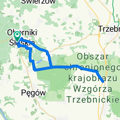
A cycling route starting in Oborniki Śląskie, Lower Silesian Voivodeship, Poland.
Overview
About this route
Łagodna trasa na rodzinną wycieczkę do kompleksu rekreacyjnego Pierwoszów/Miłocin
- -:--
- Duration
- 34.1 km
- Distance
- 127 m
- Ascent
- 125 m
- Descent
- ---
- Avg. speed
- ---
- Avg. speed

Route quality
Waytypes & surfaces along the route
Waytypes
Quiet road
21.4 km
(63 %)
Road
5.1 km
(15 %)
Surfaces
Paved
25.3 km
(74 %)
Unpaved
2.9 km
(9 %)
Asphalt
16.9 km
(50 %)
Paved (undefined)
7.7 km
(23 %)
Route highlights
Points of interest along the route
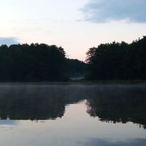
Point of interest after 17.5 km
Tren rekreacyjny Miłocin. http://www.milocin.com.pl/zwiedzanie/
Point of interest after 22.7 km
Boisko sportowe w Wiszni Małej - Przerwa na mecz
Continue with Bikemap
Use, edit, or download this cycling route
You would like to ride Miłocin or customize it for your own trip? Here is what you can do with this Bikemap route:
Free features
- Save this route as favorite or in collections
- Copy & plan your own version of this route
- Sync your route with Garmin or Wahoo
Premium features
Free trial for 3 days, or one-time payment. More about Bikemap Premium.
- Navigate this route on iOS & Android
- Export a GPX / KML file of this route
- Create your custom printout (try it for free)
- Download this route for offline navigation
Discover more Premium features.
Get Bikemap PremiumFrom our community
Other popular routes starting in Oborniki Śląskie
 Trasa relaksacyjna
- Distance
- 26.4 km
- Ascent
- 255 m
- Descent
- 302 m
- Location
- Oborniki Śląskie, Lower Silesian Voivodeship, Poland
 Wycieczka nr 1.
- Distance
- 11.3 km
- Ascent
- 288 m
- Descent
- 252 m
- Location
- Oborniki Śląskie, Lower Silesian Voivodeship, Poland
 Wycieczka nr 2.
- Distance
- 10.3 km
- Ascent
- 294 m
- Descent
- 249 m
- Location
- Oborniki Śląskie, Lower Silesian Voivodeship, Poland
 Wieczka nr 3.
- Distance
- 7.5 km
- Ascent
- 194 m
- Descent
- 195 m
- Location
- Oborniki Śląskie, Lower Silesian Voivodeship, Poland
 Wycieczka nr 4.
- Distance
- 27 km
- Ascent
- 471 m
- Descent
- 508 m
- Location
- Oborniki Śląskie, Lower Silesian Voivodeship, Poland
 drogą Stumilowego Lasu
- Distance
- 19.7 km
- Ascent
- 61 m
- Descent
- 60 m
- Location
- Oborniki Śląskie, Lower Silesian Voivodeship, Poland
 Wycieczka nr 6.
- Distance
- 9.4 km
- Ascent
- 303 m
- Descent
- 293 m
- Location
- Oborniki Śląskie, Lower Silesian Voivodeship, Poland
 Pętelka przez Wilczyn i Uraz
- Distance
- 23.3 km
- Ascent
- 62 m
- Descent
- 62 m
- Location
- Oborniki Śląskie, Lower Silesian Voivodeship, Poland
Open it in the app