

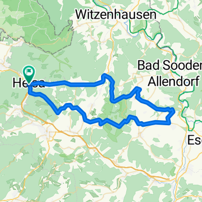
RR57km - Helsa - Hoher Meißner
A cycling route starting in Helsa, Hesse, Germany.
Overview
About this route
On the Stoppomat route Hoher Meißner
From Helsa up towards Wickerode/Großalmerode - through Wickerode and Großalmerode - in Trubenhausen turn right towards Weißenbach - climb - at the edge of Wießenbach turn right towards Laudenbach - after a short descent turn left towards Meißner Platte - after the crest at the next intersection turn left towards Bad Sooden/Frankenhain - go straight at the first fork toward Frankenhain - second turn right toward Frankenhain - before Frankenhain turn left toward Berkatal - straight through Frankershausen (Berkatal) - descend well down the valley - after Frankershausen, take the second right towards Wellingerrode - at Wellingerrode stay straight on the paved farm road to Abterrode - this is where the Stoppomat starts! Always follow the road via Vockerode to climb up the Hoher Meißner - over the summit towards Velmeden/HeLi - in the village, in the first left turn go right, then continue straight along the main street toward Rommerode - at the top of the climb go left toward HeLi/Rommerode - in Rommerode first right then left toward HeLi/Friedrichsbrück - in Friedrichsbrück turn right toward Helsa
- -:--
- Duration
- 56.3 km
- Distance
- 1,170 m
- Ascent
- 1,170 m
- Descent
- ---
- Avg. speed
- ---
- Max. altitude

Route quality
Waytypes & surfaces along the route
Waytypes
Road
10.7 km
(19 %)
Path
1.1 km
(2 %)
Surfaces
Paved
24.2 km
(43 %)
Asphalt
24.2 km
(43 %)
Undefined
32.1 km
(57 %)
Continue with Bikemap
Use, edit, or download this cycling route
You would like to ride RR57km - Helsa - Hoher Meißner or customize it for your own trip? Here is what you can do with this Bikemap route:
Free features
- Save this route as favorite or in collections
- Copy & plan your own version of this route
- Sync your route with Garmin or Wahoo
Premium features
Free trial for 3 days, or one-time payment. More about Bikemap Premium.
- Navigate this route on iOS & Android
- Export a GPX / KML file of this route
- Create your custom printout (try it for free)
- Download this route for offline navigation
Discover more Premium features.
Get Bikemap PremiumFrom our community
Other popular routes starting in Helsa
 Bergenhöferweg 8, Helsa nach Alter Weg 39, Helsa
- Distance
- 22.2 km
- Ascent
- 144 m
- Descent
- 135 m
- Location
- Helsa, Hesse, Germany
 Helsa, Spiekershausen, Helsa
- Distance
- 55 km
- Ascent
- 418 m
- Descent
- 418 m
- Location
- Helsa, Hesse, Germany
 RR57km - Helsa - Hoher Meißner
- Distance
- 56.3 km
- Ascent
- 1,170 m
- Descent
- 1,170 m
- Location
- Helsa, Hesse, Germany
 Asternweg 2, Helsa nach Asternweg 4, Helsa
- Distance
- 68 km
- Ascent
- 749 m
- Descent
- 758 m
- Location
- Helsa, Hesse, Germany
 Relaxed route in Kassel
- Distance
- 18 km
- Ascent
- 94 m
- Descent
- 190 m
- Location
- Helsa, Hesse, Germany
 fürstenhagen
- Distance
- 10.2 km
- Ascent
- 90 m
- Descent
- 110 m
- Location
- Helsa, Hesse, Germany
 Leipziger Straße 9, Helsa nach Rothenditmolder Straße 18, Kassel
- Distance
- 15.9 km
- Ascent
- 38 m
- Descent
- 131 m
- Location
- Helsa, Hesse, Germany
 Ibachweg 15B, Helsa nach Ibachweg 15A, Helsa
- Distance
- 16.9 km
- Ascent
- 354 m
- Descent
- 348 m
- Location
- Helsa, Hesse, Germany
Open it in the app