

Bentley
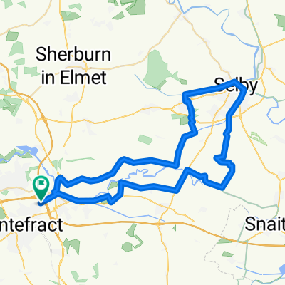
A cycling route starting in Ferrybridge, England, United Kingdom.
Overview
About this route
Fl;at untill the last 10 mile some bits of the TPT
- -:--
- Duration
- 69.7 km
- Distance
- 131 m
- Ascent
- 133 m
- Descent
- ---
- Avg. speed
- ---
- Avg. speed
Continue with Bikemap
Use, edit, or download this cycling route
You would like to ride Bentley or customize it for your own trip? Here is what you can do with this Bikemap route:
Free features
- Save this route as favorite or in collections
- Copy & plan your own version of this route
- Sync your route with Garmin or Wahoo
Premium features
Free trial for 3 days, or one-time payment. More about Bikemap Premium.
- Navigate this route on iOS & Android
- Export a GPX / KML file of this route
- Create your custom printout (try it for free)
- Download this route for offline navigation
Discover more Premium features.
Get Bikemap PremiumFrom our community
Other popular routes starting in Ferrybridge
 Bentley
- Distance
- 69.7 km
- Ascent
- 131 m
- Descent
- 133 m
- Location
- Ferrybridge, England, United Kingdom
 Royston
- Distance
- 48 km
- Ascent
- 234 m
- Descent
- 234 m
- Location
- Ferrybridge, England, United Kingdom
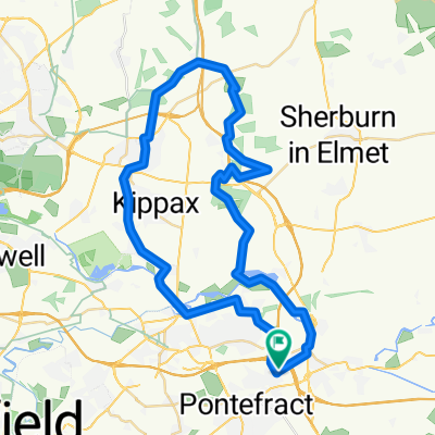
 Selby
Selby- Distance
- 50.7 km
- Ascent
- 67 m
- Descent
- 67 m
- Location
- Ferrybridge, England, United Kingdom
 High Hoyland
- Distance
- 72.2 km
- Ascent
- 500 m
- Descent
- 498 m
- Location
- Ferrybridge, England, United Kingdom
 Home to Fairburn Ings
- Distance
- 6.8 km
- Ascent
- 19 m
- Descent
- 50 m
- Location
- Ferrybridge, England, United Kingdom
 Lotherton Hall
- Distance
- 44.6 km
- Ascent
- 210 m
- Descent
- 210 m
- Location
- Ferrybridge, England, United Kingdom
 Nevison to Fairburn to Home (via Morrisons)
- Distance
- 24.2 km
- Ascent
- 740 m
- Descent
- 641 m
- Location
- Ferrybridge, England, United Kingdom
 Bramham
- Distance
- 59.2 km
- Ascent
- 222 m
- Descent
- 222 m
- Location
- Ferrybridge, England, United Kingdom
Open it in the app