

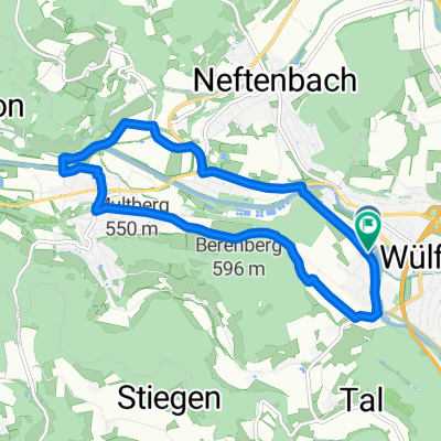
Wnterthur - Sternenberg - Winterthur
A cycling route starting in Wülflingen (Kreis 6) / Härti, Canton of Zurich, Switzerland.
Overview
About this route
Route über Sternenberg, Tösstal
- -:--
- Duration
- 75.3 km
- Distance
- 927 m
- Ascent
- 916 m
- Descent
- ---
- Avg. speed
- ---
- Avg. speed
Route quality
Waytypes & surfaces along the route
Waytypes
Road
29.7 km
(39 %)
Busy road
23.5 km
(31 %)
Surfaces
Paved
68.6 km
(91 %)
Unpaved
2 km
(3 %)
Asphalt
67.9 km
(90 %)
Pebblestone
1.6 km
(2 %)
Continue with Bikemap
Use, edit, or download this cycling route
You would like to ride Wnterthur - Sternenberg - Winterthur or customize it for your own trip? Here is what you can do with this Bikemap route:
Free features
- Save this route as favorite or in collections
- Copy & plan your own version of this route
- Sync your route with Garmin or Wahoo
Premium features
Free trial for 3 days, or one-time payment. More about Bikemap Premium.
- Navigate this route on iOS & Android
- Export a GPX / KML file of this route
- Create your custom printout (try it for free)
- Download this route for offline navigation
Discover more Premium features.
Get Bikemap PremiumFrom our community
Other popular routes starting in Wülflingen (Kreis 6) / Härti
 Wnterthur - Sternenberg - Winterthur
- Distance
- 75.3 km
- Ascent
- 927 m
- Descent
- 916 m
- Location
- Wülflingen (Kreis 6) / Härti, Canton of Zurich, Switzerland
 Haltenrebenstrasse 59A, Winterthur nach Dorfstraße 22, Lottstetten
- Distance
- 18.9 km
- Ascent
- 244 m
- Descent
- 247 m
- Location
- Wülflingen (Kreis 6) / Härti, Canton of Zurich, Switzerland
 De Wässerwiesenstrasse 65, Winterthur a Wyden 2.1, Ossingen
- Distance
- 15.9 km
- Ascent
- 171 m
- Descent
- 175 m
- Location
- Wülflingen (Kreis 6) / Härti, Canton of Zurich, Switzerland
 Weinland drive
- Distance
- 56 km
- Ascent
- 538 m
- Descent
- 509 m
- Location
- Wülflingen (Kreis 6) / Härti, Canton of Zurich, Switzerland
 Hardgutstrasse 48C, Winterthur nach J.-C.-Heer-Strasse 10.1, Winterthur
- Distance
- 55.7 km
- Ascent
- 454 m
- Descent
- 431 m
- Location
- Wülflingen (Kreis 6) / Härti, Canton of Zurich, Switzerland
 Hardgutstrasse, Winterthur nach Hardgutstrasse, Winterthur
- Distance
- 9.8 km
- Ascent
- 96 m
- Descent
- 98 m
- Location
- Wülflingen (Kreis 6) / Härti, Canton of Zurich, Switzerland
 Grosse Randenrunde
- Distance
- 100.1 km
- Ascent
- 881 m
- Descent
- 881 m
- Location
- Wülflingen (Kreis 6) / Härti, Canton of Zurich, Switzerland
 Waldtour auf und ab
- Distance
- 40.9 km
- Ascent
- 681 m
- Descent
- 682 m
- Location
- Wülflingen (Kreis 6) / Härti, Canton of Zurich, Switzerland
Open it in the app