

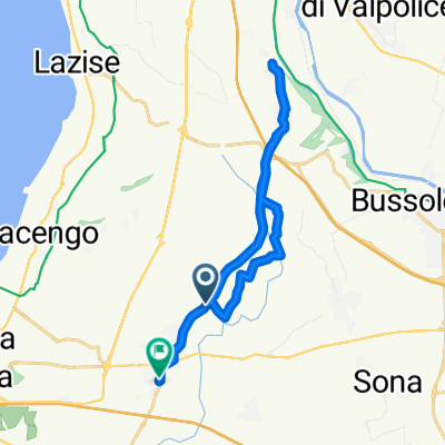
Itinerario 29
A cycling route starting in Sandrà, Veneto, Italy.
Overview
About this route
Itinerario 29
- -:--
- Duration
- 3.2 km
- Distance
- 87 m
- Ascent
- 26 m
- Descent
- ---
- Avg. speed
- ---
- Avg. speed
Route quality
Waytypes & surfaces along the route
Waytypes
Quiet road
3.2 km
(100 %)
Road
0 km
(<1 %)
Undefined
-0 km
(<1 %)
Surfaces
Paved
3.2 km
(100 %)
Asphalt
3.2 km
(100 %)
Continue with Bikemap
Use, edit, or download this cycling route
You would like to ride Itinerario 29 or customize it for your own trip? Here is what you can do with this Bikemap route:
Free features
- Save this route as favorite or in collections
- Copy & plan your own version of this route
- Sync your route with Garmin or Wahoo
Premium features
Free trial for 3 days, or one-time payment. More about Bikemap Premium.
- Navigate this route on iOS & Android
- Export a GPX / KML file of this route
- Create your custom printout (try it for free)
- Download this route for offline navigation
Discover more Premium features.
Get Bikemap PremiumFrom our community
Other popular routes starting in Sandrà
 Giro a velocità lenta in Castelnuovo del Gardalive
- Distance
- 18.6 km
- Ascent
- 208 m
- Descent
- 206 m
- Location
- Sandrà, Veneto, Italy
 Moderate route in Sandrà
- Distance
- 13.3 km
- Ascent
- 107 m
- Descent
- 106 m
- Location
- Sandrà, Veneto, Italy
 Innsbruck-Sambuco-Teil2
- Distance
- 313.4 km
- Ascent
- 440 m
- Descent
- 301 m
- Location
- Sandrà, Veneto, Italy
 Recording from 19 giu 2017, 23:06
- Distance
- 4.9 km
- Ascent
- 99 m
- Descent
- 99 m
- Location
- Sandrà, Veneto, Italy
 Tour Parco Natura Viva
- Distance
- 50.2 km
- Ascent
- 220 m
- Descent
- 220 m
- Location
- Sandrà, Veneto, Italy
 Itinerario 29
- Distance
- 3.2 km
- Ascent
- 87 m
- Descent
- 26 m
- Location
- Sandrà, Veneto, Italy
 Localita' 124, Bussolengo to Via Archetti, Tremosine sul Garda
- Distance
- 103.4 km
- Ascent
- 3,026 m
- Descent
- 3,096 m
- Location
- Sandrà, Veneto, Italy
 Strada del Gabanel 124 to Vicolo Pietro Toselli 11, Fresonara
- Distance
- 682.2 km
- Ascent
- 533 m
- Descent
- 621 m
- Location
- Sandrà, Veneto, Italy
Open it in the app