

Diner Rockburn
A cycling route starting in Sainte-Martine, Quebec, Canada.
Overview
About this route
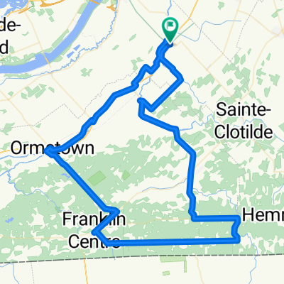
<br /> Départ Ste-Martine
Diner Pub Rockburn Covey Hill - Franklin Retour par Rang 5 - Des Écossais Chemin des Fèves - Ste-Martine (cloned from route 2157321)- -:--
- Duration
- 91.7 km
- Distance
- 240 m
- Ascent
- 244 m
- Descent
- ---
- Avg. speed
- ---
- Avg. speed
Route quality
Waytypes & surfaces along the route
Waytypes
Road
65.5 km
(71 %)
Quiet road
19.2 km
(21 %)
Surfaces
Paved
13.3 km
(15 %)
Unpaved
0.2 km
(<1 %)
Asphalt
12.9 km
(14 %)
Paved (undefined)
0.3 km
(<1 %)
Continue with Bikemap
Use, edit, or download this cycling route
You would like to ride Diner Rockburn or customize it for your own trip? Here is what you can do with this Bikemap route:
Free features
- Save this route as favorite or in collections
- Copy & plan your own version of this route
- Sync your route with Garmin or Wahoo
Premium features
Free trial for 3 days, or one-time payment. More about Bikemap Premium.
- Navigate this route on iOS & Android
- Export a GPX / KML file of this route
- Create your custom printout (try it for free)
- Download this route for offline navigation
Discover more Premium features.
Get Bikemap PremiumFrom our community
Other popular routes starting in Sainte-Martine
 Covey Hill, Sens anti- horaire
- Distance
- 52.8 km
- Ascent
- 326 m
- Descent
- 326 m
- Location
- Sainte-Martine, Quebec, Canada
 30-Parfun ontario
- Distance
- 102.9 km
- Ascent
- 186 m
- Descent
- 188 m
- Location
- Sainte-Martine, Quebec, Canada
 De Howick à Huntingdon
- Distance
- 71.9 km
- Ascent
- 158 m
- Descent
- 157 m
- Location
- Sainte-Martine, Quebec, Canada
 sainte martine court
- Distance
- 104 km
- Ascent
- 297 m
- Descent
- 297 m
- Location
- Sainte-Martine, Quebec, Canada
 Covey Hill (St-Chrysostome
- Distance
- 73.7 km
- Ascent
- 417 m
- Descent
- 417 m
- Location
- Sainte-Martine, Quebec, Canada
 Ch de la Haute-Rivière, Ste-Martine à Rue Hervé, Châteauguay
- Distance
- 5.7 km
- Ascent
- 6 m
- Descent
- 9 m
- Location
- Sainte-Martine, Quebec, Canada
 Circuit des bleuets
- Distance
- 75.8 km
- Ascent
- 207 m
- Descent
- 208 m
- Location
- Sainte-Martine, Quebec, Canada
 Circuit de la Rivière Châteauguay
- Distance
- 71.5 km
- Ascent
- 254 m
- Descent
- 253 m
- Location
- Sainte-Martine, Quebec, Canada
Open it in the app