
MTB-Ebnath Kösseine
A cycling route starting in Ebnath, Bavaria, Germany.
Overview
About this route
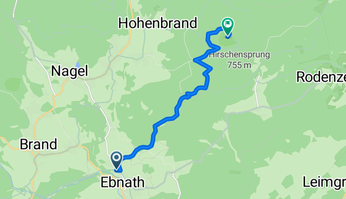
Ebnath - Kösseine - Wanderweg
- -:--
- Duration
- 7.2 km
- Distance
- 426 m
- Ascent
- 61 m
- Descent
- ---
- Avg. speed
- ---
- Avg. speed
Continue with Bikemap
Use, edit, or download this cycling route
You would like to ride MTB-Ebnath Kösseine or customize it for your own trip? Here is what you can do with this Bikemap route:
Free features
- Save this route as favorite or in collections
- Copy & plan your own version of this route
- Sync your route with Garmin or Wahoo
Premium features
Free trial for 3 days, or one-time payment. More about Bikemap Premium.
- Navigate this route on iOS & Android
- Export a GPX / KML file of this route
- Create your custom printout (try it for free)
- Download this route for offline navigation
Discover more Premium features.
Get Bikemap PremiumFrom our community
Other popular routes starting in Ebnath
 MAK-Naglersee-MAK Teil 2
- Distance
- 13.7 km
- Ascent
- 103 m
- Descent
- 257 m
- Location
- Ebnath, Bavaria, Germany
 Weissenstadt
- Distance
- 50.2 km
- Ascent
- 557 m
- Descent
- 550 m
- Location
- Ebnath, Bavaria, Germany
 Hölzlashof 7, Ebnath nach Boxdorf 20, Erbendorf
- Distance
- 15.3 km
- Ascent
- 288 m
- Descent
- 259 m
- Location
- Ebnath, Bavaria, Germany
 Glasschleif
- Distance
- 12 km
- Ascent
- 181 m
- Descent
- 176 m
- Location
- Ebnath, Bavaria, Germany
 Ebnath-Brand
- Distance
- 4.4 km
- Ascent
- 68 m
- Descent
- 18 m
- Location
- Ebnath, Bavaria, Germany
 Schwimmbadweg
- Distance
- 10.8 km
- Ascent
- 157 m
- Descent
- 234 m
- Location
- Ebnath, Bavaria, Germany
 Unnamed Road, Brand nach Tannenstraße 4, Brand
- Distance
- 7.8 km
- Ascent
- 135 m
- Descent
- 49 m
- Location
- Ebnath, Bavaria, Germany
 Route 04062015
- Distance
- 16.3 km
- Ascent
- 231 m
- Descent
- 231 m
- Location
- Ebnath, Bavaria, Germany
Open it in the app