

Dorset Coast (Wareham -- Axminster) 200Km
A cycling route starting in Wareham, England, United Kingdom.
Overview
About this route
This is the infamous Dorset Coast 200Km ride that sets out from Wareham to Axminster every April, with Audax UK.
It was my first century Audax – in fact it was my first ever Audax and first century ride that I attemted and completed quite a few years back. Afterwards I was told: "you've had a baptism of fire" – though wearing British Army issue desert boots helped reinforce this commentator's incredulity. The direction is clockwise and all starts pretty nicely having a jolly over the Sandbanks chain ferry and then riding over the Purbecks onto Weymouth. There’s a few climbs in the Purbecks but they’re just a warm up... as things are going to turn pretty nasty after - Abbotsbury Hill. This brute tops out at 20%, but that's not the problem – it just seems to go on and on; there's riders zig-zagging all over the road this decimated what “pack” there was. Many ended up pushing. Next set, repeat, “set” of killers is the three 16%s after Chideock these taking you onto Axminster. Ordnance Survey really don’t do these triplets justice on their 1:25 and 1:50,000 maps. You’re now at Axminster. Hey! Time for a nice spot of lunch at the school (scheduled stop), better fuel up real good. Feeling full? Excellent! But don’t then yak it up all over your handlebars, as immediately, (within 400 metres), after lunch it's straight back into those climbs - Sector and Stammery Hill – if you do yak it will be a pity as you’re going to need those kilocalories for later. Fret not though, at the moment you’ve a respite from all of that climbing, enjoy the scenery all the way to Uploders where, alas, things will again get seriously heavy on the hideous 1.7 miles of climbing of Spyway Hill that awaits you. After that it’s a piece of cake. Get further K-rations at Top-of-Town café Dorchester and a flat ride back to Wareham. Have a nice day. (cloned from route 274173)- -:--
- Duration
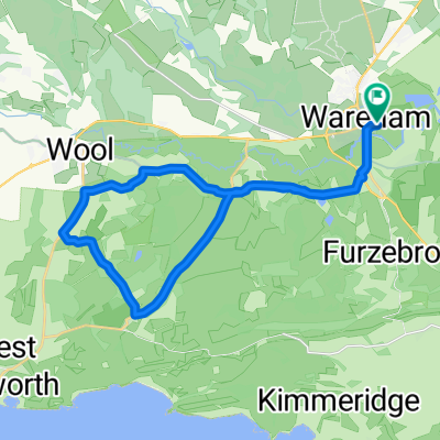
- 20.6 km
- Distance
- 66 m
- Ascent
- 75 m
- Descent
- ---
- Avg. speed
- ---
- Avg. speed

Route quality
Waytypes & surfaces along the route
Waytypes
Busy road
14 km
(68 %)
Cycleway
4.9 km
(24 %)
Surfaces
Paved
16.8 km
(82 %)
Unpaved
0 km
(<1 %)
Asphalt
16.5 km
(80 %)
Wood
0.2 km
(<1 %)
Continue with Bikemap
Use, edit, or download this cycling route
You would like to ride Dorset Coast (Wareham -- Axminster) 200Km or customize it for your own trip? Here is what you can do with this Bikemap route:
Free features
- Save this route as favorite or in collections
- Copy & plan your own version of this route
- Sync your route with Garmin or Wahoo
Premium features
Free trial for 3 days, or one-time payment. More about Bikemap Premium.
- Navigate this route on iOS & Android
- Export a GPX / KML file of this route
- Create your custom printout (try it for free)
- Download this route for offline navigation
Discover more Premium features.
Get Bikemap PremiumFrom our community
Other popular routes starting in Wareham
 Kimmeridge roure
- Distance
- 24.6 km
- Ascent
- 300 m
- Descent
- 304 m
- Location
- Wareham, England, United Kingdom
 Unnamed Road to Turbary Park Avenue 176K
- Distance
- 31.4 km
- Ascent
- 271 m
- Descent
- 253 m
- Location
- Wareham, England, United Kingdom
 RempstoneRide
- Distance
- 27.1 km
- Ascent
- 338 m
- Descent
- 337 m
- Location
- Wareham, England, United Kingdom
 Filieul Toad
- Distance
- 13.3 km
- Ascent
- 75 m
- Descent
- 74 m
- Location
- Wareham, England, United Kingdom
 Purbeck Si Jim
- Distance
- 77 km
- Ascent
- 539 m
- Descent
- 530 m
- Location
- Wareham, England, United Kingdom
 ride through Wareham
- Distance
- 15.6 km
- Ascent
- 120 m
- Descent
- 118 m
- Location
- Wareham, England, United Kingdom
 jurassic
- Distance
- 23.4 km
- Ascent
- 363 m
- Descent
- 342 m
- Location
- Wareham, England, United Kingdom
 Coombe Keynes
- Distance
- 25.5 km
- Ascent
- 873 m
- Descent
- 869 m
- Location
- Wareham, England, United Kingdom
Open it in the app