

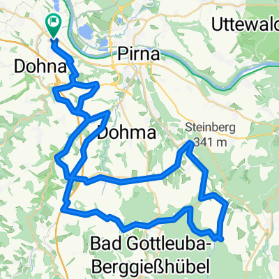
Meusegast/Müglitztal/Dresden
A cycling route starting in Heidenau, Saxony, Germany.
Overview
About this route
gefahren am 18.07.2013 bei schönem Wetter
- -:--
- Duration
- 10.9 km
- Distance
- 282 m
- Ascent
- 287 m
- Descent
- ---
- Avg. speed
- ---
- Avg. speed
Route quality
Waytypes & surfaces along the route
Waytypes
Road
5.2 km
(48 %)
Path
2.2 km
(21 %)
Surfaces
Paved
9.3 km
(86 %)
Asphalt
8.5 km
(78 %)
Paving stones
0.8 km
(8 %)
Undefined
1.5 km
(14 %)
Continue with Bikemap
Use, edit, or download this cycling route
You would like to ride Meusegast/Müglitztal/Dresden or customize it for your own trip? Here is what you can do with this Bikemap route:
Free features
- Save this route as favorite or in collections
- Copy & plan your own version of this route
- Sync your route with Garmin or Wahoo
Premium features
Free trial for 3 days, or one-time payment. More about Bikemap Premium.
- Navigate this route on iOS & Android
- Export a GPX / KML file of this route
- Create your custom printout (try it for free)
- Download this route for offline navigation
Discover more Premium features.
Get Bikemap PremiumFrom our community
Other popular routes starting in Heidenau
 Pillnitz-LIEBETHALER GRUND-BRAND-Rathen-Zschachwitz
- Distance
- 64.4 km
- Ascent
- 558 m
- Descent
- 551 m
- Location
- Heidenau, Saxony, Germany
 Wehlen - Hocksteinschänke - Stolpen - Hochland
- Distance
- 67.1 km
- Ascent
- 530 m
- Descent
- 375 m
- Location
- Heidenau, Saxony, Germany
 33. Heidenauer RTF 20.09.2014 - 60km -
- Distance
- 56.2 km
- Ascent
- 655 m
- Descent
- 656 m
- Location
- Heidenau, Saxony, Germany
 tourX
tourX- Distance
- 39.6 km
- Ascent
- 517 m
- Descent
- 572 m
- Location
- Heidenau, Saxony, Germany
 Heide-Hochland-Liebethal-Pirna
- Distance
- 59.2 km
- Ascent
- 236 m
- Descent
- 234 m
- Location
- Heidenau, Saxony, Germany
 33. Heidenauer RTF 20.09.2014 - 120 km
- Distance
- 114.6 km
- Ascent
- 900 m
- Descent
- 901 m
- Location
- Heidenau, Saxony, Germany
 LockwitztalWilischLuchau
- Distance
- 48.3 km
- Ascent
- 809 m
- Descent
- 815 m
- Location
- Heidenau, Saxony, Germany
 Schönfelder Hochlandtour
- Distance
- 44.2 km
- Ascent
- 331 m
- Descent
- 332 m
- Location
- Heidenau, Saxony, Germany
Open it in the app