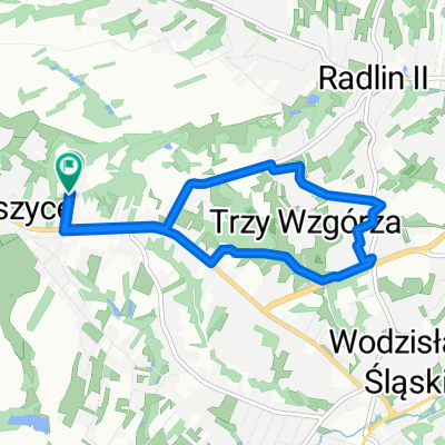
Premium Badge Download on the App Store Get it on Google Play Turn-by-turn Navigation Offline Maps Bike Type Optimized Routing Premium Maps Custom Bike Computer Export Routes Route Previews Fall Detection Premium Support

Cycling Route in Wodzis艂aw 艢l膮ski, Silesian Voivodeship, Poland

Trasa do Marysi

0
Open this route in the Bikemap app

Open this route in the Bikemap app

Open this route in Bikemap Web

Open this route in Bikemap Web

11 km
Distance
94 m
Ascent
119 m
Descent
-:-- h
Duration
-- km/h
Avg. Speed
--- m
Max. Elevation

About This Route

Jedziesz przez osiedle Jed艂ownik do Ronda na G艂o偶ynach, dalej na wprost pod górk臋 ul. Kard.Boles艂awa Kominka, potem Domejki a偶 do Rydu艂towskiej.<br /> Na skrzy偶owaniu w prawo do Radlina do skrzy偶owania w kierunku Niewiadomia, tu w lewo do艣膰 ostro w gór臋 ul. Sokolsk膮, potem z górki do skrzy偶owania przy kop. Ignacy. Jedziesz prosto ul. Ignacego Mo艣cickiego, mijasz aptek臋 i kop. z lewej, dalej jad膮c obszernym zakr臋tem w prawo doje偶d偶asz do ul. majora Brunona Janasa.

Z wytyczonej trasy wychodzi oko艂o 11 kilometrów.

This cycling route is ideal for: Road bike

You will cycle on the following surfaces: Paved

Customize this cycling route with the Bikemap route planner.

Make it yours!

Did you know? You can use this route as a template in our cycling route planner if you don't wish to start from scratch. Customize it based on your needs to plan your perfect cycling tour.

Open it in the app