
Spała ośrodek przygotowań olimpijskich
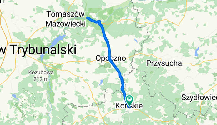
A cycling route starting in Gmina Końskie, Świętokrzyskie Voivodship, Poland.
Overview
About this route
cel -Spała ośrodek przygotowań olimpijskich
- -:--
- Duration
- 95 km
- Distance
- 215 m
- Ascent
- 216 m
- Descent
- ---
- Avg. speed
- ---
- Avg. speed
Route quality
Waytypes & surfaces along the route
Waytypes
Busy road
30.4 km
(32 %)
Quiet road
18.1 km
(19 %)
Surfaces
Paved
43.2 km
(46 %)
Unpaved
2.4 km
(3 %)
Asphalt
36.8 km
(39 %)
Paving stones
6.2 km
(7 %)
Continue with Bikemap
Use, edit, or download this cycling route
You would like to ride Spała ośrodek przygotowań olimpijskich or customize it for your own trip? Here is what you can do with this Bikemap route:
Free features
- Save this route as favorite or in collections
- Copy & plan your own version of this route
- Sync your route with Garmin or Wahoo
Premium features
Free trial for 3 days, or one-time payment. More about Bikemap Premium.
- Navigate this route on iOS & Android
- Export a GPX / KML file of this route
- Create your custom printout (try it for free)
- Download this route for offline navigation
Discover more Premium features.
Get Bikemap PremiumFrom our community
Other popular routes starting in Gmina Końskie
 trasa końskie kielce
- Distance
- 94.8 km
- Ascent
- 347 m
- Descent
- 350 m
- Location
- Gmina Końskie, Świętokrzyskie Voivodship, Poland
 Konskie 2
- Distance
- 86.2 km
- Ascent
- 406 m
- Descent
- 400 m
- Location
- Gmina Końskie, Świętokrzyskie Voivodship, Poland
 XX Jubileuszowy Konecki Maraton Rowerowy PTTK
- Distance
- 206 km
- Ascent
- 369 m
- Descent
- 371 m
- Location
- Gmina Końskie, Świętokrzyskie Voivodship, Poland
 Green Velo
- Distance
- 1,818.7 km
- Ascent
- 678 m
- Descent
- 923 m
- Location
- Gmina Końskie, Świętokrzyskie Voivodship, Poland
 Green velo
- Distance
- 1,816.5 km
- Ascent
- 3,799 m
- Descent
- 4,041 m
- Location
- Gmina Końskie, Świętokrzyskie Voivodship, Poland
 51.142, 20.408 do 51.142, 20.411
- Distance
- 0.2 km
- Ascent
- 7 m
- Descent
- 11 m
- Location
- Gmina Końskie, Świętokrzyskie Voivodship, Poland
 Route to Zachodnia 19A, 26-200 Końskie
- Distance
- 45.2 km
- Ascent
- 180 m
- Descent
- 162 m
- Location
- Gmina Końskie, Świętokrzyskie Voivodship, Poland
 objazd
- Distance
- 28.1 km
- Ascent
- 134 m
- Descent
- 124 m
- Location
- Gmina Końskie, Świętokrzyskie Voivodship, Poland
Open it in the app