

MTB-Er-Kalchreuth-Hetzleser-Berg
A cycling route starting in Buckenhof, Bavaria, Germany.
Overview
About this route
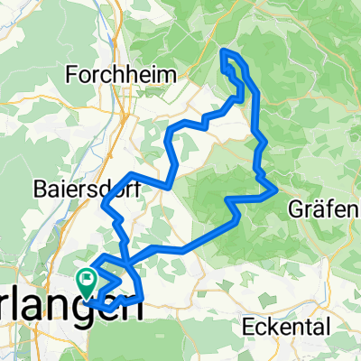
Er-Kalchreuth-Hetzleser-Berg
- -:--
- Duration
- 45.9 km
- Distance
- 529 m
- Ascent
- 529 m
- Descent
- ---
- Avg. speed
- ---
- Avg. speed
Route quality
Waytypes & surfaces along the route
Waytypes
Track
15.6 km
(34 %)
Quiet road
12.7 km
(28 %)
Surfaces
Paved
25.9 km
(56 %)
Unpaved
14.9 km
(32 %)
Asphalt
24.8 km
(54 %)
Gravel
11.6 km
(25 %)
Continue with Bikemap
Use, edit, or download this cycling route
You would like to ride MTB-Er-Kalchreuth-Hetzleser-Berg or customize it for your own trip? Here is what you can do with this Bikemap route:
Free features
- Save this route as favorite or in collections
- Copy & plan your own version of this route
- Sync your route with Garmin or Wahoo
Premium features
Free trial for 3 days, or one-time payment. More about Bikemap Premium.
- Navigate this route on iOS & Android
- Export a GPX / KML file of this route
- Create your custom printout (try it for free)
- Download this route for offline navigation
Discover more Premium features.
Get Bikemap PremiumFrom our community
Other popular routes starting in Buckenhof
 Lillachtal
- Distance
- 45.9 km
- Ascent
- 286 m
- Descent
- 285 m
- Location
- Buckenhof, Bavaria, Germany
 MTB Erlangen to Kalchreute
- Distance
- 32.9 km
- Ascent
- 228 m
- Descent
- 230 m
- Location
- Buckenhof, Bavaria, Germany
 Erlangen Standard 20km
- Distance
- 20.3 km
- Ascent
- 144 m
- Descent
- 151 m
- Location
- Buckenhof, Bavaria, Germany
 RM-MTB__Erlangen-Oedenberg_Einfach__43Km
- Distance
- 43.7 km
- Ascent
- 301 m
- Descent
- 301 m
- Location
- Buckenhof, Bavaria, Germany
 Rennrad Tour 2
- Distance
- 37.1 km
- Ascent
- 199 m
- Descent
- 187 m
- Location
- Buckenhof, Bavaria, Germany
 Erlangen Forchheim kurz
- Distance
- 32.8 km
- Ascent
- 225 m
- Descent
- 223 m
- Location
- Buckenhof, Bavaria, Germany
 RM-MTB__Walberla_66Km_920Hm
- Distance
- 66.3 km
- Ascent
- 854 m
- Descent
- 854 m
- Location
- Buckenhof, Bavaria, Germany
 Flur- und Naturdenkmale im Reichswald
- Distance
- 68.5 km
- Ascent
- 310 m
- Descent
- 315 m
- Location
- Buckenhof, Bavaria, Germany
Open it in the app