

la ruta del barro
A cycling route starting in Temuco, Región de la Araucanía, Chile.
Overview
About this route
dificultad: avanzado
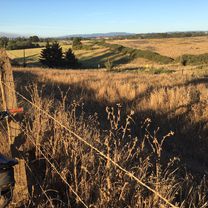
con lluvia dificil subida infernal harta agua y luces si se hace tarde la vista desde arriba es hermosa no apta para cultures xD- -:--
- Duration
- 19.4 km
- Distance
- 358 m
- Ascent
- 358 m
- Descent
- ---
- Avg. speed
- ---
- Avg. speed

Continue with Bikemap
Use, edit, or download this cycling route
You would like to ride la ruta del barro or customize it for your own trip? Here is what you can do with this Bikemap route:
Free features
- Save this route as favorite or in collections
- Copy & plan your own version of this route
- Sync your route with Garmin or Wahoo
Premium features
Free trial for 3 days, or one-time payment. More about Bikemap Premium.
- Navigate this route on iOS & Android
- Export a GPX / KML file of this route
- Create your custom printout (try it for free)
- Download this route for offline navigation
Discover more Premium features.
Get Bikemap PremiumFrom our community
Other popular routes starting in Temuco
 3 Cerros
- Distance
- 67.2 km
- Ascent
- 1,369 m
- Descent
- 1,366 m
- Location
- Temuco, Región de la Araucanía, Chile
 Cerro Ñielol Asfalto
- Distance
- 3.6 km
- Ascent
- 146 m
- Descent
- 144 m
- Location
- Temuco, Región de la Araucanía, Chile
 sendero principal
- Distance
- 2.6 km
- Ascent
- 233 m
- Descent
- 61 m
- Location
- Temuco, Región de la Araucanía, Chile
 De 3 Norte / Los Avellanos, Temuco a Los Chilcos / Los Avellanos - Sur, Temuco
- Distance
- 5.6 km
- Ascent
- 31 m
- Descent
- 31 m
- Location
- Temuco, Región de la Araucanía, Chile
 Pumalal - Monteverde 40K
- Distance
- 37.4 km
- Ascent
- 795 m
- Descent
- 795 m
- Location
- Temuco, Región de la Araucanía, Chile
 Vuelta al Cerro Mariposa
- Distance
- 25.5 km
- Ascent
- 239 m
- Descent
- 241 m
- Location
- Temuco, Región de la Araucanía, Chile
 El Álamo Express
- Distance
- 30.8 km
- Ascent
- 144 m
- Descent
- 145 m
- Location
- Temuco, Región de la Araucanía, Chile
 Ruta vuelta río cautín, puente entre rios
- Distance
- 41.4 km
- Ascent
- 187 m
- Descent
- 182 m
- Location
- Temuco, Región de la Araucanía, Chile
Open it in the app